Your cart is currently empty!
Category: Navigation Skills
-

Map Reading Skills: Essential Techniques Uncovered
Unlock the Secrets of Effective Map Reading for Adventurers
Master the Art of Decoding Map Symbols to Navigate with Confidence
Becoming adept at map reading is fundamentally rooted in your ability to interpret map symbols. These symbols represent a variety of natural and man-made features, offering critical information that is essential for navigating and exploring new terrains. A thorough grasp of these symbols streamlines your navigation experience while fostering a deeper appreciation for the beautiful landscapes around you. This knowledge significantly enhances your outdoor excursions and enriches your understanding of geography, ultimately leading to more fulfilling adventures.
Among the most frequently encountered map symbols are:
- Blue Lines: Indicate bodies of water such as rivers, lakes, and streams.
- Green Areas: Represent regions covered by forests, parks, or natural reserves.
- Black Dots: Highlight urban centers or important landmarks, including schools and hospitals.
- Brown Lines: Depict contour lines that illustrate changes in elevation and terrain shape.
- Red Lines: Typically indicate major roads or highways vital for transportation.
- Yellow Areas: Represent open spaces, agricultural fields, or recreational parks.
- Triangles: Mark hilltops or significant summits.
- Broken Lines: Represent trails or paths used for hiking or walking.
Grasping these symbols equips you with the essential skills for efficient map navigation, allowing you to effectively identify your surroundings and strategize your route with confidence.
Essential Techniques for Interpreting Contour Lines for Terrain Navigation
Understanding contour lines is crucial for effectively navigating a topographic map, as they illustrate variations in elevation and the overall shape of the terrain. These lines indicate the steepness or gradual slope of the landscape, a vital aspect for outdoor activities such as hiking, climbing, or even urban planning. By mastering the interpretation of contour lines, you can significantly enhance your ability to navigate through diverse and challenging landscapes, ensuring you are well-prepared for any obstacles you may encounter.
To differentiate between gentle and steep slopes, pay close attention to the spacing of contour lines. When these lines are closely packed together, they indicate a steep slope, suggesting a sharp incline or decline. Conversely, when the lines are spaced further apart, they signal a gentler slope. For instance, while navigating a mountainous trail, recognizing these patterns can help you assess the difficulty of an ascent, thus guiding your preparation. Furthermore, understanding contour intervals, which represent the vertical distance between adjacent lines, provides crucial insights into changes in elevation, significantly aiding in route planning and ensuring your safety.
The Critical Role of Map Scale in Navigation Success
Map scale is a fundamental concept that illustrates the relationship between distances represented on the map and their actual distances in the real world. A solid understanding of scale is essential for effective navigation, ensuring that your distance estimations remain accurate. Various types of map scales exist, each serving unique purposes and contexts.
Typically, there are three primary types of map scales: graphic, verbal, and ratio. A graphic scale features a line marked with distances that can be measured directly against the map, allowing for straightforward calculations. A verbal scale expresses the relationship in words, such as “1 inch equals 1 mile.” Lastly, a ratio scale, for instance, 1:50,000, indicates that one unit on the map corresponds to 50,000 of the same units in reality. A firm grasp of these scale types ensures you can accurately measure distances while traversing various terrains, whether navigating through dense forests, urban areas, or scaling rugged mountain paths.
Effective Strategies to Improve Your Map Reading Skills

Proven Techniques for Accurately Orienting Your Map in the Field
Achieving accurate orientation is paramount for effective navigation, particularly in unfamiliar environments. Mastering the skill of orienting a map involves aligning it with the surrounding landscape, a technique that can be enhanced through the use of a compass. This practice not only improves your geographical awareness but also fosters confidence during outdoor adventures, making navigation a more enjoyable and rewarding experience.
For proper map orientation, lay the map flat and rotate it until the north on the map aligns with the magnetic north indicated by your compass. For example, while hiking on the Appalachian Trail, this method ensures your map aligns precisely with the natural features surrounding you, facilitating effective route planning. By utilizing a compass alongside your map, you can successfully monitor your progress, assess landmarks, and make well-informed decisions regarding your path. Consistently practicing this technique in various environments will further enhance your skills and ensure you navigate confidently, regardless of your location.
Best Practices for Effective and Efficient Map Reading
Implementing best practices in map reading guarantees that navigators can interpret maps accurately and efficiently, leading to safer and more enjoyable outdoor experiences. Enhancing your map reading skills can be achieved through structured practice and strategic training, empowering you to significantly improve your navigation capabilities.
To elevate your map reading skills, consider these actionable strategies:
- Practice Regularly: Dedicate time to reading different types of maps in various environments to build familiarity and confidence.
- Join Outdoor Groups: Engage with seasoned navigators who can offer guidance, tips, and share valuable insights on effective navigation.
- Utilise Online Resources: Access tutorials and courses that focus on map reading techniques and skill enhancement.
- Set Navigation Challenges: Use maps to navigate new trails or urban settings, gradually increasing difficulty levels to build proficiency.
- Simulate Real-World Scenarios: Create exercises that mimic emergency situations requiring proficient map reading skills.
- Record Your Progress: Maintain a journal of your navigation experiences to track improvements and identify areas needing focus and development.
By adopting these practices, you can significantly elevate your map reading proficiency and feel more secure navigating diverse landscapes, enriching your outdoor adventures and experiences.
Advanced Strategies for Mastering the Art of Map Reading
Once you have mastered the fundamentals of map reading, employing advanced strategies can significantly enhance your skills, enabling you to navigate complex terrains with confidence and ease. Mastering these techniques prepares you to handle various environments, whether you are hiking in the Andes or traversing the vast expanses of the Sahara Desert.
One effective advanced strategy involves multitasking between different types of maps, such as topographic and thematic maps. For instance, using a topographic map alongside a thematic map that highlights local flora and fauna deepens your understanding of the environment. This approach allows you to connect the physical features of the terrain with the ecosystems you encounter. Additionally, leveraging technology, such as augmented reality apps, can provide real-time overlays of information on your surroundings, giving you a modern advantage in navigation.
Another valuable strategy is to develop mental maps, which involve visualizing the landscape based on your map reading. This technique reinforces your navigational skills, especially when you find yourself away from digital devices or traditional maps. By routinely applying these advanced strategies, you can refine your map reading abilities and cultivate a more robust understanding of your environment.
Avoiding Common Mistakes in Map Reading: Key Tips for Success
Recognizing common mistakes in map reading can be transformative for novice navigators, helping to prevent potential mishaps while enhancing the overall experience. Awareness of these pitfalls allows you to approach map reading with increased confidence and accuracy, leading to successful navigation outcomes.
Frequent errors in map reading include:
- Ignoring Scale: Failing to consider the map scale can lead to significant miscalculations in distances, which can affect your route decisions.
- Misinterpreting Symbols: Confusion over map symbols can result in navigating towards incorrect landmarks, causing delays and frustration.
- Neglecting Contour Lines: Overlooking elevation changes can pose safety risks, particularly in mountainous areas where terrain can be unpredictable.
- Relying Solely on GPS: Over-dependence on digital navigation can erode essential map reading skills, making you vulnerable in areas with poor signal.
- Not Orienting the Map: Starting with a non-oriented map can lead to disorientation in the field, complicating your navigation efforts.
- Skipping Practice: Infrequent practice can hinder skill development and diminish confidence, making navigation more challenging.
- Failing to Account for Environmental Changes: Not updating your route based on recent changes in the terrain can lead to navigational errors, especially in dynamic environments.
To avoid these mistakes, always double-check your scale, practice regularly, and engage with fellow navigators for advice and feedback. Incorporating these strategies into your navigational routine will enhance your map reading skills and overall outdoor experience.
Essential Tools and Technologies to Elevate Your Map Reading Skills
Reliable Traditional Tools for Accurate Navigation
Despite the rise of digital navigation tools, traditional map reading instruments such as compasses and protractors remain indispensable in various situations. Understanding their advantages over digital alternatives can significantly enhance your navigation skills and ensure you’re well-prepared for any circumstance you may face.
Traditional tools offer reliability and durability that electronic devices may lack. For instance, compasses operate independently of batteries and are immune to electronic interference, making them essential in remote areas where GPS signals may be unreliable or nonexistent. Furthermore, using traditional tools fosters a deeper connection with the landscape, as users must actively engage with the physical map and comprehend its features, rather than simply relying on digital cues. Moreover, learning to use traditional tools cultivates essential skills and promotes self-reliance, which can be crucial in emergencies or off-grid situations.
Incorporating traditional tools into your navigational practices allows for a well-rounded skill set, ensuring you are equipped to effectively handle various challenges. Having both traditional and digital tools at your disposal creates a robust navigation strategy, enabling you to tackle any environment with confidence and skill.
Innovative Digital Mapping Applications Transforming Navigation
Digital mapping applications have revolutionized the way we interact with maps, offering advanced tools that enhance navigation and exploration. These applications provide dynamic features capable of complementing traditional map reading techniques, resulting in a more integrated approach to navigation and outdoor activities.
One significant advantage of digital mapping apps is their ability to deliver real-time updates and detailed information about your surroundings. Many applications, such as Google Maps or AllTrails, feature user-generated content, showcasing current trail conditions, hazards, and points of interest. This interactivity allows you to adjust your plans based on crowd-sourced data, making your navigation experience more efficient and informed.
To effectively integrate digital maps with traditional techniques, consider using your smartphone’s GPS to complement your compass. For example, while hiking in a national park, monitor your progress using the app while periodically checking your compass to maintain orientation. This hybrid approach ensures that you remain proficient in traditional navigation while benefiting from the convenience and features of modern technology.
Combining GPS with Traditional Maps for Enhanced Navigation
The advent of GPS technology has dramatically improved navigation by providing real-time location data, significantly enhancing the effectiveness of traditional maps. Understanding how to utilize GPS in conjunction with maps can create a powerful navigational toolkit that enhances your outdoor experiences.
When employing GPS alongside maps, several key considerations must be acknowledged. First, ensure your GPS device is fully charged and functional before heading into areas where power sources may be scarce. Additionally, familiarize yourself with the terrain and features depicted on both the GPS and the map to avoid confusion in dense areas. For instance, while trekking through thick forests, relying solely on GPS could lead to disorientation in an environment where landmarks are obscured.
Furthermore, it’s wise to frequently cross-reference your GPS location with the map to ensure accuracy, particularly in unfamiliar areas. By regularly verifying your position, you can avoid common pitfalls associated with solely relying on technology. This balanced approach to navigation promotes a deeper understanding of your environment and builds greater confidence in your map reading skills, ensuring you are always prepared for any situation.
How Enhanced Map Reading Skills Can Transform Your Navigation Experience
Improving Your Directional Awareness through Proficient Map Reading
Map reading skills are pivotal in enhancing your sense of direction, which is essential for navigating unfamiliar territories. By developing these skills, you can significantly boost your confidence and ability to explore new environments, whether wandering through the bustling streets of Tokyo or the vast landscapes of Patagonia.
Engaging in map reading teaches you to understand the spatial relationships between various landmarks and features. This cognitive process enhances your ability to visualize your surroundings, making it easier to orient yourself and select the best route to your destination. For instance, if you are hiking in the Canadian Rockies, the ability to identify peaks, valleys, and water sources on a map can drastically improve your navigation experience. You will be able to utilize both the map and your surroundings to gauge direction, distances, and potential hazards, leading to a safer journey.
Moreover, practicing map reading in diverse environments equips you with a broader understanding of geography, which can be beneficial for everyday navigation. Whether traversing urban settings or natural landscapes, being adept at reading maps fosters a keen sense of direction and spatial awareness, which is invaluable for any adventurer looking to explore new territories with confidence.
Effective Strategies for Planning Efficient Routes Using Maps
Planning efficient routes is a critical aspect of effective navigation, enabling you to reach your destination swiftly and safely. Developing this skill through map reading can lead to significant time savings and a more enjoyable exploration experience, allowing you to maximize your outdoor adventures.
To plan the best routes using maps, begin by identifying your destination and evaluating the key features depicted on your map. Look for trails, roads, or paths that lead you directly to your target while considering elevation changes indicated by contour lines. For instance, while planning a hike through the Swiss Alps, identifying the most accessible trails that avoid steep inclines can lead to a more enjoyable experience, helping you conserve energy and appreciate the scenery.
Utilizing landmarks as reference points during your route planning can also prove beneficial. By marking important features such as rivers, peaks, or towns on your map, you can create a mental checklist for your journey. Additionally, consider factors such as the weather, terrain conditions, and potential hazards when planning your route to ensure that you choose the safest and most efficient path. By honing your route-planning skills, you can navigate with confidence, maximizing your outdoor experiences and ensuring a memorable adventure.
Essential Emergency Navigation Techniques for Safety and Preparedness
In emergency situations, possessing strong map reading skills can be vital for survival. Knowing how to navigate effectively when stakes are high can be the difference between safety and danger. Developing these essential map reading techniques ensures you are prepared to handle unexpected circumstances with confidence and skill.
One critical technique involves learning to identify and utilize landmarks for navigation. In emergencies, natural features such as rivers, mountains, and valleys can serve as reliable reference points. For example, if you find yourself lost in a dense forest during a hiking trip and your GPS fails, recognizing nearby hills or water sources on your map can guide you back to safety and provide a sense of direction.
Another important skill is the ability to estimate distances and determine your location using contour lines and map scales. In urgent situations, knowing how far you need to travel to reach safety can help you prioritize your actions effectively. Additionally, practicing triangulation, a method where you use two known points to ascertain your position, can enhance your navigational accuracy during emergencies, providing a reliable way to find your way back on track.
By mastering these emergency navigation techniques, you will feel more at ease and prepared for any unforeseen challenges while exploring various environments, ensuring your safety and well-being during outdoor adventures.
Utilizing Topographical Features for Enhanced and Safe Navigation
Understanding topographical maps is integral to improving navigation, as they provide detailed insights into the physical features of the landscape. By utilizing these maps effectively, you can identify landmarks, elevation changes, and terrain characteristics, leading to more accurate navigation and better decision-making.
Topographical features such as contour lines, ridges, and valleys offer valuable information about the terrain. For instance, when navigating through mountainous areas, being aware of elevation changes can help prepare you for physical challenges and assist in route planning, ensuring you can manage your energy levels effectively. Knowing where to find water sources, like rivers or lakes, can also significantly impact your journey, especially in remote regions where resources may be scarce.
Moreover, utilizing topographical features to identify potential hazards, such as cliffs or steep drops, is crucial for your safety. For example, while hiking in the Appalachian Mountains, recognizing the contours of the terrain can guide you in avoiding dangerous areas that may not be evident on a simple map. By integrating knowledge of topographical maps into your navigation practices, you can improve both your safety and overall experience in the great outdoors, leading to more enjoyable and secure adventures.
Applying Map Reading Skills Across Various Recreational Activities
Mastering Map Reading for Memorable Hiking Experiences
Accurate map reading is essential for hikers, ensuring safe navigation through diverse trails and terrains. By honing your map reading skills, you can significantly enhance your outdoor experience, empowering you to explore the beauty of nature with confidence and assurance.
When embarking on a hike, the first step is to select a reliable map that provides comprehensive details about the trail, including elevation changes, water sources, and significant landmarks. Familiarizing yourself with the map symbols and contour lines allows you to assess the difficulty of your chosen trail effectively. For instance, if you are hiking in the Rocky Mountain National Park, understanding the elevation profile can help you prepare for changes in altitude and energy expenditure, ensuring a safer and more enjoyable hike.
Moreover, practicing map reading during hikes can lead to improved skills over time, enhancing your confidence and enjoyment. Use your map to mark key points of interest, such as scenic vistas or picnic spots, which will enrich your overall experience. Regular practice in diverse environments will also equip you with the confidence to navigate new trails independently, ensuring that you can maximize your hiking adventures to their fullest potential.
Orienteering: The Fusion of Map Reading and Physical Activity
Orienteering merges the excitement of navigation with physical challenges, making map reading a crucial skill for success in this sport. Participants must use maps and compasses to navigate through various terrains, fostering a strong relationship between navigation and physical fitness.
To excel in orienteering, developing a solid understanding of map symbols and contours is essential. Familiarizing yourself with the terrain depicted on the map allows you to make informed decisions about your route. For example, understanding which areas are densely forested or have steep slopes will aid in determining the best path during a race or challenge, optimizing your performance and enjoyment.
Additionally, practicing with different types of maps and courses can further enhance your skills. Participating in local orienteering events provides valuable experience and allows you to learn from more seasoned navigators. The more you engage with this activity, the more adept you will become at quickly interpreting maps, making split-second decisions, and navigating complex environments, all of which are critical for success in orienteering.
Map Reading in Water-Based Recreational Activities for Enhanced Safety
Maps are equally essential in water-based activities, such as sailing, kayaking, or canoeing. Understanding how to read maps specific to aquatic environments can significantly enhance safety and navigation skills, ensuring enjoyable experiences while engaging in these recreational pursuits.
In water-based activities, nautical charts are often employed, providing crucial information about water depths, currents, and navigational hazards. Learning to interpret these charts is vital for ensuring safe travel across rivers or oceans. For instance, when kayaking in the Great Barrier Reef, understanding the depth and tidal patterns outlined on nautical charts can help you avoid dangerous areas and optimize your route for a safer journey, preventing potential accidents.
Moreover, integrating traditional map reading skills with digital applications can enhance your navigation capabilities. Utilizing GPS alongside nautical charts allows for real-time updates on your location and surrounding features, ensuring a more comprehensive understanding of your environment. By mastering map reading in water settings, you can navigate confidently while exploring diverse aquatic landscapes, maximizing your enjoyment and safety.
Identifying the Challenges of Effective Map Reading
Common Mistakes to Watch for in Map Reading
Recognizing common mistakes in map reading can drastically enhance your navigational skills. By being aware of these pitfalls, you can avoid unnecessary challenges and enhance your overall outdoor experience, ensuring a safer and more enjoyable journey.
Frequent errors include:
- Overlooking Scale: Ignoring the scale can lead to gross miscalculations of distances, causing navigational issues.
- Confusing Symbols: Misinterpreting map symbols can result in navigating to the wrong location, wasting time and energy.
- Neglecting Terrain Features: Failing to consider elevation changes can impact route planning and safety, especially in challenging terrains.
- Relying on Memory: Attempting to memorize routes without reference can lead to disorientation and confusion.
- Ignoring Map Updates: Using outdated maps can result in navigating through closed trails or altered landscapes, leading to frustration.
- Not Practicing: Infrequent practice can lead to a lack of confidence and skill erosion, making navigation more difficult.
- Assuming Uniformity: Expecting all terrain types to be similar can lead to misjudgment of route difficulties and safety risks.
To address these mistakes, ensure you regularly practice using various maps, clarify any uncertainties regarding symbols, and always verify your route before embarking on your journey. Adopting these strategies will contribute significantly to your overall navigation success and confidence.
Effective Strategies to Overcome Map Reading Challenges
Overcoming challenges in map reading is essential for mastering this critical skill. Various difficulties can arise, but understanding how to address them will improve your proficiency and confidence in navigation, ensuring you can explore safely and efficiently.
One common challenge involves interpreting contour lines, which can initially seem daunting. To tackle this, practice regularly with topographic maps, honing your ability to recognize patterns and understand elevation changes. Additionally, seeking guidance from experienced navigators or participating in workshops can provide valuable insights and tips to enhance your understanding and skills.
Another difficulty may involve adjusting to different map types. To overcome this challenge, expose yourself to various maps, including road maps, topographic maps, and digital applications. Each map format presents unique features and reading techniques, and familiarizing yourself with these variations will build your adaptability and confidence in navigation.
By actively engaging with these challenges and seeking solutions, you will develop a deeper connection with map reading, ultimately improving your navigational skills and enhancing your overall outdoor experiences, allowing for more enjoyable adventures.
Adapting to Diverse Map Types for Successful Navigation
Different map types require nuanced reading skills, and adapting your approach is vital for effective navigation. Understanding the unique characteristics of various maps allows you to utilize them optimally in different contexts, enhancing your navigational effectiveness.
For instance, topographic maps necessitate a focus on contour lines and elevation changes, while road maps emphasize routes and distances. Familiarizing yourself with the symbols and scales of each map type is essential for successful navigation. For example, when planning a road trip across Europe, you would prioritize a road map’s route information while remaining aware of topographical features that may affect travel time and challenges.
Another type, thematic maps, focus on specific data and trends, such as population density or climate zones. Adapting your map reading skills to extract relevant information from these maps is crucial for application in various fields, such as urban planning or environmental studies. By embracing the diversity of map types and enhancing your ability to adapt your reading approach, you will improve your navigation skills and broaden your understanding of the world around you.
Research-Backed Benefits of Proficient Map Reading Skills
Cognitive Enhancements Gained through Map Reading Practices
Engaging in map reading offers numerous cognitive benefits that extend beyond navigation. Regularly interpreting maps enhances various cognitive skills, contributing to overall mental agility and spatial awareness, which are crucial for everyday decision-making and problem-solving.
One primary cognitive advantage is improved memory retention. The process of memorizing routes, landmarks, and map symbols engages various parts of the brain, strengthening neural connections and enhancing recall. Additionally, map reading fosters critical thinking and problem-solving skills, as navigators must analyze various factors to determine the best route or strategy. For instance, navigating a complex urban landscape requires quick decision-making and adaptability to sudden changes in the environment.
Furthermore, map reading supports enhanced spatial reasoning abilities. Understanding how different elements on a map relate to one another cultivates a greater awareness of spatial relationships in the real world. This increased spatial awareness proves particularly beneficial for activities such as architecture, engineering, and even everyday tasks like arranging furniture or navigating new environments.
By embracing the cognitive benefits of map reading, you not only improve your navigation skills but also cultivate a more agile and adaptable mind, enhancing both personal and professional growth in various aspects of life.
Enhancing Spatial Awareness through Effective Map Reading Techniques
Spatial awareness is closely linked to effective map reading skills, as both involve understanding how objects relate to one another in space. Developing your map reading skills significantly contributes to enhanced spatial understanding, which is crucial for various activities, from navigation to engineering and design.
When reading maps, individuals learn to visualize their surroundings and comprehend the relationships between landmarks, terrains, and routes. This skill translates to everyday life, enabling individuals to navigate unfamiliar environments with greater ease and confidence. For example, when exploring a new city, effectively reading a city map allows you to orient yourself and identify important locations such as restaurants, attractions, and transportation options.
Moreover, spatial awareness fosters better decision-making abilities. By developing a nuanced understanding of how distances and directions relate to one another, you can make well-informed choices about your routes and activities. Engaging in map reading regularly will enhance your spatial awareness, resulting in a more intuitive approach to navigation and exploration, ultimately leading to more rewarding experiences.
Long-Term Benefits of Mastering Map Reading Skills for Lifelong Exploration
Long-term engagement with map reading can yield significant advantages, both personally and professionally. By developing and maintaining map reading skills, individuals can enhance their navigation capabilities and open doors to new opportunities for exploration and adventure.
One key advantage is the establishment of a strong foundation for outdoor activities. As you become more proficient in map reading, you can confidently explore a wide range of terrains, from mountains to forests, leading to enriched recreational experiences and a deeper connection to nature. Additionally, these skills can enhance your involvement in environmental conservation, hiking groups, or adventure sports, fostering connections with like-minded individuals and communities who share your passion for exploration and the outdoors.
On a professional level, strong map reading skills are beneficial in fields such as urban planning, geography, or environmental science. Employers often seek individuals who can interpret spatial data and utilize maps effectively. By mastering these skills, you position yourself as a valuable asset in various industries that require navigation and spatial analysis, opening up new career paths and opportunities.
Ultimately, embracing map reading as a lifelong skill can provide you with a wealth of opportunities for personal growth, exploration, and professional advancement, enriching your life experiences and broadening your horizons.
Proven Strategies for Elevating Your Map Reading Skills
Building a Regular Map Reading Practice for Improved Skills
Establishing a consistent map reading routine is essential for enhancing your proficiency in navigation. By committing to structured practice, you can build confidence and improve your skills over time, making you a more effective navigator in any situation you may encounter.
To create an effective map reading routine, start by dedicating specific times each week for practice. Engage in various activities, such as reading diverse types of maps, exploring new areas, or participating in navigation challenges. For example, set aside an hour every weekend to explore a local park or hiking trail with your map in hand, actively applying your skills in real-world settings to reinforce your learning.
Additionally, incorporate diverse environments into your routine. Practicing in urban, rural, and wilderness settings will broaden your understanding of various map types and improve your adaptability in different contexts. You can also set personal goals, such as mastering specific map features or completing a certain number of navigation challenges each month to track your progress and achievements.
By building a structured map reading routine, you will reinforce your skills and cultivate a deeper appreciation for navigation, ultimately enhancing your outdoor experiences and confidence in your abilities as a navigator.
Leveraging Resources to Enhance Your Map Reading Skills
Various resources can significantly aid in improving your map reading skills, providing valuable tools for practice and learning. By leveraging these resources, you can accelerate your development and achieve greater confidence in navigation, leading to more successful and enjoyable outdoor experiences.
Consider these beneficial resources:
- Online Courses: Enroll in courses that focus on map reading and navigation skills to enhance your understanding and practical application.
- Books and Guides: Read literature on navigation techniques and map interpretation to deepen your knowledge and insights.
- Navigation Apps: Utilize mobile apps that offer tutorials and practice exercises to refine your skills and familiarize yourself with different map types.
- Local Clubs: Join outdoor or navigation clubs where you can learn from experienced members, share insights, and participate in group activities.
- YouTube Tutorials: Watch instructional videos that demonstrate effective map reading techniques and tips for improving your skills.
- Navigation Challenges: Participate in local orienteering events to practice your skills in real-world scenarios, enhancing your experience and confidence.
- Map Collections: Access a variety of maps for different terrains and environments for hands-on practice and exposure to diverse navigation contexts.
By actively incorporating these resources into your learning process, you will enhance your map reading abilities and gain valuable insights into navigation techniques, ensuring you develop a well-rounded skill set that prepares you for various adventures.
Commitment to Continuous Improvement in Map Reading Skills
Continuous improvement is key to mastering map reading, as regular practice fosters growth and confidence in your navigational skills. By implementing effective methods, you can ensure long-term development in your map reading abilities and maintain your proficiency in navigation.
To continuously enhance your map reading skills, consider the following strategies:
- Regular Practice: Make map reading a part of your routine, exploring different terrains and environments to broaden your experience and adaptability.
- Seek Feedback: Collaborate with experienced navigators who can provide constructive criticism and suggestions for improvement in your skills.
- Track Your Progress: Keep a journal to document your experiences, challenges, and improvements over time, providing valuable insights into your growth and areas for further development.
- Set Goals: Establish specific, measurable objectives for your map reading skills and work diligently towards achieving them to maintain motivation and focus.
- Engage in Workshops: Attend map reading and navigation workshops to learn from experts and network with fellow enthusiasts who share your passion for navigation.
- Experiment with Different Maps: Challenge yourself to read and interpret various map types to build adaptability and versatility in different navigation contexts.
- Cultivate a Growth Mindset: Embrace challenges as learning opportunities, concentrating on long-term skill development and improvement in your navigation abilities.
By committing to continuous improvement in your map reading skills, you will cultivate a strong foundation in navigation that will serve you well in various outdoor endeavors and activities, enhancing your overall experiences as an adventurer and navigator.
Frequently Asked Questions (FAQs) About Map Reading
What are the essential skills required for effective map reading?
Essential skills include understanding map symbols, reading contour lines, interpreting scales, and accurately orienting maps to your surroundings for effective navigation.
How can I enhance my map reading skills effectively?
Engage in regular practice with different types of maps, participate in outdoor activities, and attend navigation courses or workshops to build your expertise and confidence in navigation.
Why is understanding map scale crucial for navigation?
Understanding map scale helps you accurately measure distances and assess the size of features in the real world, which is essential for effective navigation in various terrains.
Which tools are essential for traditional map reading?
Essential tools include a compass, protractor, and high-quality paper maps that detail the specific area of interest for navigation, ensuring reliability and accuracy.
How do contour lines help indicate slope steepness?
Contour lines that are closer together signify steeper slopes, while those spaced further apart indicate gentler terrain, guiding your route selection and helping assess trail difficulty.
What is the role of GPS in enhancing map reading skills?
GPS provides real-time location data, which enhances navigation when used alongside traditional maps for improved accuracy and situational awareness during outdoor activities.
How can I effectively use maps for hiking?
Select detailed maps of the trails, understand terrain features, and regularly consult your map during the hike to monitor progress and make informed decisions regarding your route.
What are some common mistakes to avoid in map reading?
Common mistakes include overlooking the scale, misinterpreting symbols, neglecting to orient the map correctly before navigation, and failing to practice regularly to maintain skills.
How does map reading contribute to cognitive skill development?
Map reading enhances memory retention, critical thinking, and spatial reasoning abilities, significantly contributing to overall cognitive development and mental agility, which benefits various aspects of life.
What are the long-term benefits of practicing map reading regularly?
Regular practice builds confidence, hones navigational skills, and prepares you for diverse outdoor experiences and challenges, enhancing your overall navigation proficiency and enjoyment of exploration.
Explore our world on X!
The post Map Reading Skills: Essential Techniques Unveiled appeared first on Survival Bite.
The Article Map Reading Skills Unveiled: Essential Techniques Explained Was Found On https://limitsofstrategy.com
-

Survival Compass: Key Navigation Tips and Techniques
Unlock the Secrets of Compass Navigation: Essential Knowledge and Techniques
Understanding the Compass: The Indispensable Tool for Navigation
A compass is an essential navigational tool that empowers adventurers and explorers to identify directions concerning the Earth’s magnetic poles. This deceptively simple device typically features a magnetized needle that consistently points towards magnetic north, allowing users to orient themselves in unknown terrains. Understanding the intricate workings of a compass is crucial for effective navigation, whether you’re traversing dense forests, expansive deserts, or remote wilderness. Despite its straightforward design, the compass serves a vital role; it acts as a reliable guide for hikers, adventurers, and survivalists, enabling them to navigate with confidence even when modern gadgets might fail.
The functionality of a compass is based on the principles of magnetism, which magnetically aligns the needle with magnetic north. This pivotal concept has been instrumental for explorers and travelers throughout history, guiding them through uncharted territories. Contemporary compasses often incorporate degree markers for precise bearings. Mastering compass usage extends beyond grasping its mechanics; it requires honing the skills necessary for practical application across diverse scenarios.
Diverse Types of Compasses: Choosing the Right One for Your Navigation Needs
There are numerous types of compasses, each tailored for specific navigation requirements and environmental contexts. The most prevalent types include baseplate compasses, lensatic compasses, and digital compasses. Baseplate compasses are particularly popular among hikers and outdoor enthusiasts because of their flat base and transparent casing, which allows users to overlay maps and align them with the compass needle effortlessly. This design is incredibly useful for accurately plotting courses and mapping out routes.
In contrast, lensatic compasses are preferred by military personnel and serious navigators due to their precision and resilience. These compasses include a rotating bezel and a sighting lens, which facilitate accurate readings over long distances. They excel in harsh weather conditions and rugged terrains. Digital compasses, often integrated into smartphones and GPS devices, provide modern conveniences such as electronic readouts and compatibility with mapping software. However, depending on digital compasses can be problematic in remote regions where battery life and signal strength may falter.
Selecting the most suitable type of compass largely depends on individual needs, the navigation environment, and the user’s experience level. Each compass type offers unique advantages, making it critical to understand their functionalities before embarking on any adventure.
Mastering Compass Reading: Essential Techniques for Accurate Navigation
Effectively reading a compass entails mastering its various components, including the needle, dial, and direction-of-travel arrow. To accurately determine your heading, hold the compass steady and level, ensuring that the needle aligns with the north marker on the dial. The direction-of-travel arrow indicates the path you should follow, simplifying the process of adhering to a specific bearing.
To skillfully read a compass, begin by locating your current position on a map and identifying your intended destination. Next, utilize the compass to establish a bearing from your current location to the target point. Align the compass dial with the direction you plan to travel, and then read the degree marking located directly beneath the direction-of-travel arrow. This numerical value will effectively guide you throughout your journey, ensuring you stay on course.
An important factor to consider when reading a compass is magnetic declination, which refers to the angular difference between magnetic north and true north. Since declination varies depending on your geographical location, it is crucial to adjust your compass reading accordingly. This adjustment is vital for maintaining precision in navigation, particularly in remote areas where accurate direction is essential.
Expert Strategies for Using a Compass in Varied Terrains
Navigating with Precision: Using a Compass Across Different Terrains
Successfully navigating various terrains with a compass requires an understanding of how environmental factors can influence compass readings. Each type of landscape—whether mountainous, forested, or flat—presents unique challenges and considerations for effective navigation. For instance, in mountainous regions, steep slopes can lead to inaccuracies in compass readings due to magnetic interference from geological formations.
- In mountainous terrains, adjust for elevation changes and potential magnetic interference.
- In dense forests, obscured landmarks make compass usage vital for maintaining direction.
- In deserts, vast open spaces complicate orientation; utilize distant landmarks as reference points.
- Urban environments may present challenges due to buildings and metallic objects disrupting compass readings, necessitating extra caution.
- In polar regions, magnetic anomalies can occur; trust your compass but verify with additional navigation tools.
- Coastal areas require attention to tides and potential land shifts that could affect your positioning.
- During nighttime navigation, ensure your compass is well-lit for visibility.
- In adverse weather conditions, protect your compass from moisture to maintain accurate readings.
Understanding these factors greatly enhances your ability to navigate safely in diverse environments, ensuring that your compass serves as a reliable ally rather than a confusing liability. Mastering the unique characteristics of different terrains empowers you to utilize your compass with assurance, regardless of where your adventure leads you.
Enhancing Compass Accuracy: Techniques for Precise Navigation
The accuracy of a compass can be affected by various external elements, including nearby metal objects and electrical fields. These factors can result in deviations in compass readings, leading to potential navigational errors. To enhance accuracy, it is crucial to implement specific measures to effectively mitigate these influences.
First and foremost, always remain aware of your surroundings. Avoid taking compass readings near significant metal objects, such as vehicles or fences, as they can disrupt the needle’s alignment. Instead, seek out an open space with minimal magnetic interference. Taking multiple readings can also significantly improve accuracy; by averaging several readings, you can compensate for any anomalies that may arise.
Additionally, consider employing a technique known as “swinging the compass,” which involves rotating the compass in a full circle and noting the highest and lowest readings. This approach helps identify any interference and allows you to adjust your bearings accordingly. Regular calibration is essential as well; ensure your compass is periodically checked for any signs of wear or malfunction.
- Keep your compass away from metal objects to prevent interference.
- Take multiple readings and average them for a more accurate direction.
- Swing the compass to identify discrepancies in readings caused by environmental interference.
- Regularly calibrate your compass to maintain its accuracy and functionality.
By implementing these techniques, you can significantly enhance the reliability of your compass, making it a trusted ally for navigation in various situations.
Best Practices for Maintaining Your Compass for Optimal Performance
Regular maintenance of your compass is vital to ensure its longevity and reliability as a navigation tool. A well-maintained compass not only performs better but can also be a lifesaver in critical navigation situations. The first step in maintenance is to keep the compass clean; dirt or moisture can disrupt the needle’s movement, so regularly wipe the exterior with a soft, dry cloth.
Keeping the compass dry is particularly crucial, especially when navigating in wet conditions. Store your compass in a protective case to prevent exposure to extreme temperatures, which can damage its delicate components. Additionally, periodically check its functionality; a simple test involves observing the needle’s movement to ensure it swings freely. If you notice any bubbles in the liquid inside the compass, it may indicate a need for repair or replacement.
Be vigilant about strong electromagnetic fields, which can cause malfunctions. If your compass features a mirror or sighting capability, ensure these parts are clean and free from scratches that can impair visibility.
- Keep your compass clean and dry to ensure accurate readings.
- Store your compass in a protective case to shield it from extreme temperatures.
- Regularly check for functionality, ensuring the needle moves freely.
- Be mindful of strong electromagnetic fields that may interfere with compass readings.
- Clean lenses and mirrors, if present, to enhance visibility and functionality.
- Periodically calibrate your compass to maintain accuracy.
By adhering to these best practices, you can ensure that your compass remains a dependable tool for navigation, always ready to guide you through any adventure.
Combining Compass and Map for Effective Navigation
How to Orient a Map Using Your Compass for Accurate Navigation
Orienting a map with a compass is a fundamental navigational skill that significantly enhances your ability to accurately plot your course. This process involves aligning the map’s north with the compass needle’s north, creating a clear understanding of your surroundings. To begin, lay the map flat on a surface and hold your compass level. Rotate the map until the north marker aligns with the north-pointing needle of the compass.
Once the map is oriented, you can start plotting your route effectively. Identify your current location on the map and determine your desired destination. Next, use the compass to take a bearing from your location to your destination by aligning the direction-of-travel arrow with your intended path. This bearing will serve as your guide, enabling you to follow a precise route.
It’s essential to memorize or note significant landmarks along your path to assist navigation. If you stray off course, refer back to your compass and map to reorient yourself. Practicing this skill in various environments will build your confidence and competence, ensuring you can navigate effectively, even in unfamiliar territories.
Steps for Plotting a Course on a Map: A Comprehensive Guide
Plotting a course on a map using a compass is an essential navigational skill that merges map reading with navigational techniques. To start, identify your starting point and intended destination on the map clearly. Use the compass to determine the bearing—the direction you need to travel—by aligning the direction-of-travel arrow with your starting point and destination.
Once you establish your bearing, rotate the compass dial to match the degree marking with the direction-of-travel arrow. This provides a clear visual guide of the path you need to follow. It’s vital to double-check your bearing and ensure it accounts for any magnetic declination specific to your location, as this can significantly impact your navigation accuracy.
While following your plotted course, consistently monitor your surroundings and use prominent landmarks as reference points. This practice will help you stay oriented and allow for necessary adjustments. Should you encounter obstacles or detours, do not hesitate to recalibrate your route using the compass and map to maintain direction.
Mastering this technique not only enhances your navigational skills but also equips you with the confidence to explore new areas without the fear of becoming lost.
Techniques to Enhance Your Map Navigation Skills
Several techniques can significantly enhance your map navigation skills, enabling you to pinpoint your location more accurately and efficiently. One highly effective method is triangulation, which involves taking bearings from two or more known landmarks to establish your precise position. By drawing lines on the map from these landmarks based on their respective bearings, you can identify your exact location at the intersection point.
Another valuable technique is resection, which allows you to determine your position relative to known points on the map effectively. To perform resection, take a bearing to a prominent landmark and plot the line of direction on your map. Repeat this process for a second landmark, and where the lines intersect indicates your current location.
Understanding the concept of dead reckoning is also essential for effective navigation. This technique involves estimating your current position based on direction and distance traveled from a known starting point. Combine this method with regular compass checks to maintain accuracy and adjust your course as necessary.
Familiarizing yourself with these techniques through consistent practice will enhance your confidence and expertise in map navigation, making you a more adept navigator in any environment.
Advanced Techniques for Effective Compass Navigation
Navigating with a Compass at Night: Strategies for Safe Exploration
Night navigation with a compass presents unique challenges, necessitating specific techniques to ensure safe and accurate navigation. One crucial aspect is to use a flashlight to read the compass without interfering with its operation. Avoid shining the light directly on the compass needle or dial, as this could cause temporary visual impairment, making it difficult to read the compass accurately.
To facilitate navigation during the night, consider using reflective markers along your path. These markers can help you identify landmarks or route features without relying solely on visibility. Familiarizing yourself with the terrain during daylight hours can provide a mental map for nighttime navigation, allowing you to move with confidence.
Another effective tactic is to memorize crucial bearings before darkness falls. This preparation enables you to navigate efficiently without frequently stopping to consult the compass. Keep your compass secured to prevent loss, and utilize a lanyard or clip to ensure it remains easily accessible.
By employing these strategies, you can significantly enhance your night navigation skills, ensuring that your compass remains a dependable tool, guiding you safely through the dark.
Effective Strategies for Compass Navigation in Adverse Weather Conditions
Navigating in adverse weather conditions requires special considerations to ensure effective use of a compass. Rain, fog, and snow can obscure visibility and complicate compass readings. Protecting your compass from moisture is vital; consider using a waterproof case or cover to shield it from the elements.
When visibility is limited, clarity in compass readings becomes crucial. Opt for a lensatic compass, known for its precision and durability under challenging conditions. The magnifying lens enables you to read small details even in poor visibility, ensuring more accurate navigation.
It’s advisable to take shorter bearings more frequently in adverse weather. This practice helps maintain your orientation and prevents straying off course. Additionally, familiarizing yourself with the terrain before adverse weather strikes—having a mental map of key landmarks—can effectively guide your movement despite visibility challenges.
By preparing for adverse weather conditions and adjusting your navigation tactics accordingly, you can enhance your compass skills and overall navigational proficiency.
Using a Compass in Conjunction with Other Navigation Tools: A Comprehensive Approach
Integrating a compass with other navigation tools can significantly enhance your navigation capabilities, providing a comprehensive understanding of your position and route. One effective approach is to combine your compass with a GPS device. While GPS devices offer accurate positioning information, they can fail in remote areas or due to battery depletion. In such instances, relying on your compass ensures that you remain oriented and can continue navigating effectively.
Incorporating an altimeter into your navigation toolkit can provide additional context, especially in mountainous regions. Knowing your altitude can assist in terrain interpretation and help make informed decisions about potential hazards. For instance, when traversing steep slopes, a combination of compass and altimeter can facilitate safe and efficient navigation.
Another practical technique is to utilize a map and compass together to cross-reference information. While the compass offers direction, the map provides a detailed view of the terrain, allowing for better route planning and hazard assessment. Regularly switching between these tools can enhance your overall situational awareness and ensure you are well-equipped for any navigation challenge.
By effectively integrating various navigation tools, you can create a multifaceted approach that enhances your skills and confidence when navigating diverse environments.
Avoiding Common Mistakes in Compass Navigation
Understanding Magnetic Declination: Avoiding Common Misunderstandings
One of the most frequent mistakes in compass use is misunderstanding magnetic declination. Failing to account for this factor can lead to significant navigational errors, as the difference between true north and magnetic north varies by location. This variation can be considerable, particularly in areas far from the magnetic equator; ignoring it can result in veering off course.
To avoid this pitfall, it is essential to check the local declination for your area before embarking on your journey. Most maps include declination information, allowing you to adjust your compass readings accordingly. By making the necessary adjustments for declination, you can ensure that your navigation remains accurate and effective.
Additionally, consider regularly updating your knowledge of local declination, as it can change over time due to geological shifts. Understanding this concept and incorporating it into your navigation practice will greatly enhance your compass skills, enabling you to traverse various terrains with confidence.
Recognizing Potential Sources of Compass Interference: A Critical Consideration
Disregarding sources of interference is another frequent mistake that can lead to inaccurate compass readings. Metal objects, electronic devices, and even certain geological formations can disrupt the compass needle’s alignment, causing deviations in your readings. This interference can result in navigational errors, particularly when navigating in urban environments or areas with significant metal infrastructure.
To avoid this error, always be mindful of your surroundings when using a compass. Maintain a safe distance from large metal objects, such as vehicles or fences, which can distort compass readings. If you suspect interference, consider relocating to an open area where you can take a reading without distractions.
Regularly checking your compass for accuracy is also crucial. If you notice any unusual fluctuations in the needle’s movement, reassess your environment and adjust your position accordingly. Developing an awareness of potential sources of interference will enhance your navigational skills and ensure reliable readings.
Strategies for Effectively Avoiding Compass Errors
Avoiding compass errors involves adopting a disciplined approach to navigation that incorporates multiple strategies. Regular calibration is key; frequently check your compass for accuracy, ensuring that the needle moves freely and reliably. Understanding your compass’s limitations is equally essential; each type of compass has specific features and functionalities, and being aware of them will help you use the tool more effectively.
Practicing proper usage techniques, such as holding the compass level and avoiding sudden movements, can also minimize errors. Consistently taking bearings and comparing them against your surroundings will help maintain direction and ensure accuracy. If you experience discrepancies, reevaluate your position and adjust your course based on additional readings.
Moreover, practicing navigation in diverse environments will build your proficiency and confidence. The more experience you gain, the better equipped you will be to handle unexpected challenges and avoid potential compass errors.
The Consequences of Neglecting Proper Compass Use: What to Avoid
Neglecting proper compass use is a mistake that can lead to significant navigation errors and, ultimately, becoming lost. Keeping the compass level is essential; tilting it can disrupt the needle’s movement, leading to inaccurate readings. Furthermore, failing to take accurate bearings may result in misjudging your position and direction, potentially causing confusion and disorientation.
To avoid these pitfalls, develop a thorough understanding of how to hold and use your compass effectively. Familiarize yourself with its features and practice taking readings consistently. Use reference points and landmarks to guide your journey, and don’t hesitate to consult your compass frequently, particularly in challenging environments.
Establishing a routine for proper compass use will build confidence and competence as a navigator. The significance of accuracy in navigation cannot be overstated, and adopting disciplined practices ensures reliable compass function, allowing you to explore new terrains confidently.
The Research-Backed Advantages of Mastering the Survival Compass Guide
Enhancing Your Survival Skills Through Compass Mastery
A compass can significantly improve survival skills by providing a reliable means of navigation, crucial in unfamiliar or wilderness environments. Many adventurers and survivalists assert the life-saving capabilities of a compass in challenging situations. For instance, in a survival scenario where modern technology fails, a compass offers a straightforward method to ascertain direction and navigate back to safety or find essential resources.
Consider the situation of hikers lost in a remote area. By effectively utilizing a compass, they can navigate towards known landmarks or trails, substantially increasing their chances of returning safely. Understanding how to use a compass alongside a map further enhances survival skills, enabling individuals to plot their course accurately, assess their surroundings, and make informed decisions regarding their movements.
This reliance on a compass underscores the importance of navigation skills in outdoor survival situations. Mastering this tool not only equips individuals with the ability to navigate but also fosters an attitude of preparedness and resilience in the face of challenges.
Building Confidence Through Compass Use: The Psychological Benefits
Utilizing a compass can greatly enhance confidence in navigation, as it offers a tangible method to determine direction and track progress, thereby reducing the likelihood of becoming lost. This confidence stems from understanding how to use the compass effectively, empowering individuals to explore new terrains without the anxiety of disorientation.
For many, the fear of getting lost in unfamiliar environments can be overwhelming. However, mastering compass skills alleviates this concern. Knowing that you possess a reliable tool to guide you provides reassurance, enabling you to focus on the journey and enjoy the experience rather than worrying about finding your way.
Building confidence in navigation also involves regular practice and familiarity with the compass. Engaging in outdoor activities that challenge your navigation skills will enhance your competence, reinforcing your ability to use the compass effectively. The more confident you become, the more likely you will venture into new environments and embrace the spirit of adventure.
The Psychological Comfort Offered by Compass Use: Fostering Resilience
Using a compass can offer psychological comfort and reassurance, knowing you have a tool to guide you back to safety. This sense of security can significantly reduce stress and anxiety in challenging situations, allowing individuals to remain focused and calm during navigation.
In survival scenarios, maintaining composure is crucial for making sound decisions. A compass acts as a lifeline, providing direction and clarity, which can be particularly valuable when faced with uncertainty. The ability to trust your compass fosters a sense of control, allowing you to navigate challenges with determination and purpose.
Additionally, the simple act of engaging with the compass can serve as a grounding experience. In moments of chaos or fear, turning to a compass provides a tactile connection to the environment, reinforcing your awareness of your surroundings. This connection can enhance mindfulness, promoting a sense of presence and reducing feelings of panic.
Ultimately, the psychological benefits of using a compass extend beyond navigation; they enhance overall mental resilience, enabling individuals to face challenges with confidence and clarity.
Facilitating Effective Decision-Making with a Compass
A compass aids in making informed decisions by providing accurate directional information, essential for choosing the right path in survival situations. When faced with choices about which route to take, a compass allows you to assess your options more effectively.
For example, if confronted with multiple paths in a forest, using a compass to determine which direction aligns with your intended destination can simplify the decision-making process. This reliance on a compass streamlines navigation and alleviates the intellectual burden of relying solely on memory or intuition.
Effective decision-making is also enhanced by the ability to identify potential hazards and opportunities in your surroundings. By integrating compass readings with map navigation, you can better assess risks, such as steep inclines or challenging terrain, and make more informed choices about your route.
The combination of accurate direction and situational awareness allows you to navigate with confidence, ensuring that your decisions lead you toward safety or desirable outcomes. In survival scenarios, this ability to make effective decisions can be crucial, directly impacting your chances of success.
Practical Applications of Compass Navigation
Effective Compass Use During Hiking: Strategies for Success
Hiking with a compass involves setting a bearing, following it, and periodically checking your progress to ensure you stay on course. The key to successful navigation during a hike lies in understanding how to read the compass and apply that knowledge to the landscape around you. Start by determining your current location on the map and setting a bearing towards your desired destination.
As you follow your bearing, regularly check your compass to confirm that you are maintaining the correct direction. If you find that you have strayed off course, reassess your position using prominent landmarks and recalibrate your path accordingly. This practice not only ensures that you remain oriented but also reinforces your understanding of the terrain.
Additionally, familiarize yourself with the terrain features ahead of time. This knowledge will help you anticipate challenges, such as rivers or steep inclines, and allow for effective decision-making along your route. By using a compass in conjunction with your map, you can confidently explore new trails and navigate back to safety if necessary.
Hiking with a compass is not only a practical skill but also adds an enriching layer to your outdoor experience, allowing you to connect with nature while honing your navigation abilities.
The Advantages of Using a Compass During Camping: Enhancing Your Experience
Employing a compass during camping expeditions can help you explore new areas safely, return to camp easily, and navigate back to civilization if needed. A compass serves as an essential tool that enhances your camping experience, enabling you to venture beyond established trails and discover hidden gems in nature.
Throughout your camping trip, utilize the compass to familiarize yourself with the surrounding area. Setting waypoints can enhance your navigation, allowing you to track your path and return to camp reliably. By marking specific points on the map and taking bearings, you can explore with greater confidence and avoid becoming disoriented.
In emergencies, a compass can prove invaluable. If you find yourself separated from your group or lost, relying on your compass can guide you back to familiar territory or the nearest road. The ability to navigate effectively can significantly enhance your overall camping experience, ensuring you can enjoy your time outdoors without fear of losing your way.
Ultimately, incorporating compass use into your camping routine promotes a sense of adventure and self-sufficiency, making each trip more rewarding and memorable.
Using a Compass in Emergency Situations: Navigating to Safety
In emergencies, a compass can be a lifesaver by helping you navigate to safety, locate help, or return to a known location. When technology fails—such as when GPS devices run out of battery or lose signal—having a compass on hand provides a reliable means of direction, ensuring you can find your way even in the most challenging situations.
In a survival scenario, the first step is to assess your surroundings and determine your location. By using the compass to establish a bearing towards known landmarks or escape routes, you can make informed decisions about your next steps. This methodical approach is vital in high-stress situations, where clarity and direction are paramount.
Furthermore, the ability to navigate through difficult terrain, such as dense forests or rugged mountains, can be enhanced with a compass. By maintaining accurate bearings and adjusting based on your surroundings, you can systematically traverse obstacles and move towards safety.
Ultimately, mastering compass navigation equips you with the skills necessary to handle emergencies with confidence, ensuring that you can rely on this essential tool when it matters most.
Proven Strategies for Mastering the Survival Compass Guide
Teaching Compass Navigation Skills: A Step-by-Step Approach
Teaching compass navigation involves demonstrating the basics, practicing in a controlled environment, and gradually increasing the complexity of navigation scenarios. Begin by introducing the main components of the compass, including the needle, dial, and direction-of-travel arrow. Explain how each part functions and the importance of aligning the compass with the map.
Once the basics are understood, engage your students in hands-on practice in a familiar environment. Set clear objectives, such as taking a bearing to a specific landmark. Encourage them to take multiple readings and assess their accuracy. As they gain confidence, introduce more complex activities, such as triangulation and resection, to enhance their skills.
Additionally, sharing real-world examples and personal anecdotes related to compass navigation can reinforce the material and foster enthusiasm and connection to the subject. Provide constructive feedback and encourage questions to ensure a thorough understanding of compass navigation techniques.
By breaking down the learning process into manageable steps and promoting active engagement, you can effectively teach others the invaluable skill of compass navigation.
Developing a Personal Navigation Plan: Essential Steps for Success
Developing a navigation plan involves setting clear objectives, selecting the right tools, and preparing for different scenarios to ensure effective navigation. Start by identifying your intended destination and any potential hazards you might encounter along the way. This foresight will help you anticipate challenges and make informed decisions about your route.
Next, choose the appropriate navigational tools for your journey. While a compass is essential, consider integrating a map, GPS device, or altimeter to enhance your navigation capabilities. Knowing which tools to use and when will provide greater flexibility and reliability in your navigation.
Additionally, prepare for various scenarios by considering potential changes in weather, terrain, or visibility. Developing contingency plans and alternative routes will ensure that you remain adaptable during your journey. This proactive approach to navigation not only enhances your overall preparedness but also instills confidence in your ability to navigate effectively.
Ultimately, creating a personal navigation plan is about cultivating a mindset of awareness and readiness. This preparation will empower you to tackle any challenges that arise, ensuring a safer and more enjoyable navigation experience.
Key Elements of an Effective Navigation Strategy: A Comprehensive Guide
An effective navigation strategy encompasses understanding your environment, employing multiple navigation tools, and regularly updating your plan based on changing conditions. Begin by familiarizing yourself with the terrain, including key landmarks, elevation changes, and potential hazards. This knowledge will enhance your situational awareness and inform your navigation decisions.
Incorporating multiple navigation tools, such as a compass, map, and GPS device, allows for greater flexibility and accuracy. Each tool provides unique insights; together, they create a comprehensive understanding of your surroundings and position. Regularly consult and cross-reference these tools to ensure you are on the right path.
Moreover, be prepared to adapt your navigation strategy based on new information or changing conditions. Weather changes, unexpected obstacles, or new information about your route can all necessitate adjustments. Regularly reassessing your plan and remaining flexible will enhance your ability to navigate with confidence and success.
Incorporating these key elements into your navigation strategy will empower you to traverse any environment with assurance, ensuring you can reach your destination safely.
Maintaining and Calibrating Your Compass: Tips for Optimal Performance
Regular maintenance and calibration are essential for ensuring compass accuracy, which is crucial for effective navigation. Begin by keeping your compass clean and free from moisture. Regularly wipe the exterior with a soft cloth and check for signs of wear or damage that could impact its functionality.
Calibration is a vital aspect of maintaining your compass’s accuracy. Start by checking for bubbles in the liquid; if present, it may indicate a need for repair. Additionally, calibrate your compass in a magnetically neutral area to avoid interference from external sources. Follow the manufacturer’s guidelines for your specific compass model to ensure the best calibration practices.
It is also advisable to periodically test your compass against known bearings to assess its accuracy. This practice will help you identify discrepancies early on and adjust your navigation approach as necessary.
By regularly maintaining and calibrating your compass, you ensure its reliability as a navigation tool, making it an indispensable part of your outdoor preparedness.
Using a Compass Effectively in Emergency Situations: Strategies for Success
In emergencies, relying on your compass for navigation is crucial. Understanding how to use a compass effectively under stress can make the difference between safety and confusion. Begin by familiarizing yourself with the compass features, allowing you to operate it instinctively when needed.
In low-visibility situations, such as fog or darkness, remain calm and take your time to read the compass carefully. Utilize a flashlight when necessary, but avoid shining it directly on the compass to maintain visibility. It’s also wise to have a backup light source, as reliable visibility is essential for accurate readings.
Know how to navigate without relying solely on visual cues. By memorizing key bearings or establishing mental notes about your surroundings, you can navigate effectively even when visibility is compromised. This preparedness, combined with the reliable guidance of a compass, will empower you to make informed decisions during emergencies.
Ultimately, mastering compass navigation techniques equips you with the skills and confidence necessary to handle emergency situations adeptly, ensuring you can find your way to safety when it matters most.
Frequently Asked Questions About Compass Use: Clarifying Common Concerns
What Is the Primary Function of a Compass?
The primary function of a compass is to provide directional guidance relative to the Earth’s magnetic poles, assisting users in navigating effectively through various environments.
How Do I Make Adjustments for Magnetic Declination?
To adjust for magnetic declination, consult the local declination value for your area and add or subtract that value from your compass reading based on the direction of magnetic north.
Can I Effectively Use a Compass in Urban Settings?
Yes, you can use a compass in urban settings, but be aware of potential interference from metal structures and electronic devices, which may affect accuracy.
What Should I Do If My Compass Needle Is Not Moving Smoothly?
If the compass needle is not moving smoothly, inspect for bubbles in the liquid, dirt, or damage. Clean the compass and recalibrate it if necessary; if issues persist, consider replacing the device.
How Can I Enhance My Compass Skills?
Enhancing compass skills involves regular practice, learning various navigation techniques, and familiarizing yourself with different terrains to boost your confidence and proficiency.
Is a Digital Compass as Reliable as a Traditional Compass?
A digital compass can be reliable, but it depends on battery life and technology. In remote areas, traditional compasses are often more dependable, as they do not rely on electronic components.
What Should I Do If I Become Lost While Hiking?
If you become lost while hiking, remain calm, retrieve your compass, and assess your surroundings. Use the compass to determine your direction, retrace your steps if possible, and look for familiar landmarks.
Can Weather Conditions Impact Compass Readings?
Yes, weather conditions such as heavy snow, rain, or fog can obscure visibility and affect your ability to read the compass accurately, so exercise caution in adverse conditions.
How Frequently Should I Calibrate My Compass?
You should calibrate your compass periodically, especially before embarking on a journey or if you notice discrepancies in readings. Regular checks are essential for ensuring accuracy.
What Is the Best Type of Compass for Beginners?
A baseplate compass is often recommended for beginners due to its simplicity, ease of use, and compatibility with maps, making it an excellent starting point for learning navigation skills.
Explore our world on X!
The post Survival Compass Guide: Essential Tips for Navigation appeared first on Survival Bite.
The Article Survival Compass: Essential Navigation Tips and Tricks Was Found On https://limitsofstrategy.com
-

Compass Reading Basics for Navigating Effectively
Comprehensive Guide to Compass Components and Their Practical Applications
Discover the Essential Parts of a Compass and Their Functions
Grasping the fundamentals of Compass Reading Basics is essential for proficient navigation. A compass is a vital instrument for outdoor adventurers, comprising various key components that work in unison to provide accurate directional guidance. Whether your adventures take you hiking in the rugged mountains, wandering through dense forests, or exploring urban settings, understanding these components is crucial for enhancing your navigation abilities. Each element plays a pivotal role in the compass’s functionality, making it an invaluable asset for explorers.
- Magnetic Needle: The magnetic needle is the core component of the compass, engineered to rotate freely and align itself with the Earth’s magnetic field, consistently pointing towards magnetic north.
- Housing: The housing functions as a protective enclosure for the magnetic needle, often displaying degree markings to facilitate precise navigation.
- Baseplate: The transparent baseplate enables users to view both the compass and a map simultaneously, greatly enhancing navigation accuracy.
- Direction-of-Travel Arrow: This arrow indicates your intended movement direction, ensuring you stay on your planned route.
- Orienting Arrow: Found within the housing, the orienting arrow assists in aligning the compass with north as depicted on a map, ensuring accurate directional readings.
- Compass Rose: The compass rose, a circular diagram on the housing, illustrates cardinal directions (North, South, East, West) and degree markings, serving as an essential navigation reference.
- Index Line: The index line is a reference line aiding in taking precise bearings by aligning with the direction-of-travel arrow.
Each component is vital for the effective operation of the compass. Understanding how these parts interact allows you to maximize the utility of your compass, whether you’re hiking through the magnificent Andes, sailing the tranquil waters of the Mediterranean, or navigating the lush forests of Southeast Asia.
Techniques for Holding Your Compass to Achieve Maximum Accuracy
Mastering the correct technique for holding a compass is crucial for obtaining reliable readings. Using the proper method ensures that the magnetic needle can move freely without interference from your hand or surrounding objects. To hold your compass effectively, adhere to the following straightforward guidelines.
Begin by placing your compass flat in the palm of your hand. Ensure that the baseplate remains stable and level to minimize any disruptions that could affect the needle’s movement. With the direction-of-travel arrow facing away from you, use your thumb to stabilize the baseplate while your fingers grip the sides for support. This grip is essential for maintaining a steady hold, which is vital for accurate navigation.
It is equally important to keep the compass horizontal. Any tilt can lead to erroneous readings. For instance, when navigating a rocky trail in the Rocky Mountains, make sure your compass remains level to achieve precise bearings.
In environments with fluctuating temperatures, such as high-altitude regions, be mindful of your compass’s sensitivity. Cold temperatures can slow the needle’s response, while warm air may create pockets that disrupt accuracy. Always take the time to hold your compass correctly, particularly in challenging conditions.
The Importance of the Magnetic Needle in Navigation Success
The magnetic needle is the focal point of the compass, making it indispensable for successful navigation. It aligns with the Earth’s magnetic field, providing critical orientation as you traverse diverse terrains. Understanding the behavior of the magnetic needle is essential for navigating effectively, whether you are exploring the Appalachian Trail or the arid landscapes of Namibia.
The magnetic needle operates under the influence of the Earth’s magnetic field, which can vary in intensity and direction based on your geographical location. This variance underscores the importance of being aware of your surroundings; techniques that work in one area may not be applicable in another. For example, in the Northern Hemisphere, the needle points toward magnetic north, which may differ from true north depending on your exact position.
When navigating, it’s vital to consider how nearby magnetic objects can influence the needle’s response. Metal structures, electronic devices, and other compasses can distort readings. To mitigate this, always take readings away from potential sources of magnetic interference, especially in urban areas like New York City or during outdoor activities in densely wooded regions.
Effectively utilizing the magnetic needle requires regular practice and situational awareness. Engaging in compass reading exercises, such as orienteering events held globally, will enhance your instinctive understanding of the needle’s behavior, boosting your overall navigational skills.
Steps to Accurately Orient Your Compass with a Map

Orienting your compass with a map is a fundamental skill vital for effective navigation. This process ensures your map accurately reflects the terrain you are traversing, allowing for more precise direction-setting. Here’s a step-by-step guide to achieving this efficiently.
Start by laying your map flat on a stable surface or holding it directly in front of you. Position the compass along the edge of the map so that the direction-of-travel arrow points towards the top of the map, which generally indicates north. Once correctly positioned, rotate both the map and the compass together until the magnetic needle aligns with the orienting arrow within the compass housing. This alignment confirms that your map is accurately oriented to real-world conditions, whether you are hiking along the coastal pathways of the Pacific Northwest or navigating the bustling streets of Tokyo.
After successfully orienting your map, utilize the compass to take bearings for specific points marked on the map. For example, if you’re trekking in the awe-inspiring Swiss Alps and wish to reach a particular summit, find that summit on your map, align the compass with the direction-of-travel arrow, and note the bearing to guide your adventure.
It’s crucial to revisit this orientation process whenever you change locations or encounter significant topographical changes. Maintaining the compass’s orientation is essential for ensuring accuracy, particularly in challenging environments like dense forests or mountainous areas where landmarks are scarce.
The Significance of Understanding Declination in Navigation
Declination refers to the angular difference between true north and magnetic north, making it a crucial factor in achieving accurate compass readings. Understanding how to adjust for declination is essential for enhancing your navigational precision across various global locations.
Magnetic declination varies by region and is subject to change over time due to shifts in the Earth’s magnetic field. In certain areas of the United States, declination may reach several degrees east or west, while in some European regions, it might be minimal. To determine your local declination, consult a compass declination chart or utilize online resources that provide updated information based on your coordinates.
To adjust for declination, first ascertain whether you need to add or subtract degrees based on your location’s declination value. If the declination is east, add the degrees to your compass reading; if it is west, subtract them. For instance, if you’re navigating near the coast of California and the declination indicates an east deviation of 10 degrees, you would add that to your bearing for precise navigation.
Neglecting to account for declination could lead to significant navigational errors, especially in remote wilderness areas where even minor inaccuracies can result in getting lost. Regularly recalibrating your understanding of declination based on current maps will help ensure you maintain accuracy in your compass readings, whether you are traversing the rugged landscapes of Patagonia or the expansive plains of Mongolia.
Proficient Techniques for Mastering Compass Reading
Explore Techniques Used by Navigation Professionals for Accurate Compass Readings

Navigation experts utilize a variety of techniques aimed at enhancing the accuracy of compass readings, ensuring confident traversal through diverse landscapes. Two of the most effective methods are triangulation and back-bearing, both crucial for precise navigation.
Triangulation involves taking bearings from two or more recognizable landmarks. By identifying these reference points and measuring the angles between them using your compass, you can accurately determine your precise location on a map. For example, while hiking through the Andes, if you spot three distinct peaks, take bearings to each one and plot them on your map. The intersection of these bearings will reveal your exact location, a valuable technique when traditional landmarks are obscured or less visible.
Back-bearing is another essential technique that enables navigators to verify their current course. To perform a back-bearing, take the bearing you just traveled and add or subtract 180 degrees to identify the direction from which you came. This method proves especially useful in dense environments, such as jungles or urban settings, where retracing your steps can help confirm your navigational accuracy.
Mastering these techniques requires practice, but they significantly bolster your ability to navigate complex terrains. Regular participation in activities like orienteering or wilderness survival courses can provide invaluable real-world experience, further solidifying these expert techniques in your navigation toolkit.
Strategies to Enhance Your Compass Reading Skills
Improving your compass reading skills is a systematic process that combines practice, understanding, and exposure to diverse environments. Whether preparing for a hiking expedition in the Alps or participating in a local orienteering event, following structured steps can elevate your proficiency.
One effective method for enhancing your skills is to practice regularly in various settings. Choose different terrains, such as forests, urban areas, or mountainous landscapes, and use your compass to navigate. This exposure helps you become familiar with how environmental factors influence compass readings and enables you to adapt your approach effectively.
Engaging in navigation challenges can also serve as valuable practice. Set specific goals, such as locating a hidden checkpoint within a designated area using only your compass and map or participating in local orienteering events. These challenges compel you to apply your compass skills under pressure, reinforcing your capabilities and boosting your confidence.
In addition to hands-on practice, studying various navigational techniques can further enhance your skills. Explore literature or attend workshops led by experienced navigators, focusing on advanced topics such as declination adjustments and environmental influences on compass readings. Seeking mentorship from seasoned navigators can provide personalized feedback, refining your understanding and application of compass reading.
Ultimately, improvement stems from a combination of regular practice, exposure to diverse navigational scenarios, and continuous learning. Over time, you will become more proficient and confident in using your compass, whether navigating through the vast landscapes of Australia or the intricate trail systems of the Scottish Highlands.
Exploring Advanced Features of Compasses and Their Applications
Modern compasses are equipped with a range of advanced features designed to enhance navigational accuracy, especially in challenging conditions. Familiarizing yourself with these features can significantly elevate your navigation skills, whether you are exploring the rugged terrain of the Rockies or sailing the open seas.
One notable feature is adjustable declination, allowing you to set your compass according to your specific location’s declination. This function is invaluable for those who frequently travel or navigate across different regions, eliminating the need for manual adjustments each time you take bearings.
Another essential feature found in many modern compasses is luminous markings, which facilitate visibility in low-light conditions. This is particularly beneficial for night navigation or during foggy weather, ensuring you can read your compass accurately despite environmental challenges. Additionally, some compasses come with built-in clinometers, which measure slope angles, particularly advantageous for hikers and climbers needing to assess terrain steepness.
Another advanced feature is the sighting scope, typically found in more specialized compasses. This allows for precise bearings on distant landmarks by aligning them with the direction-of-travel arrow. Such precision becomes crucial when navigating vast wilderness areas or when specific landmarks are scarce.
Mastering these advanced features not only enhances your navigation capabilities but also prepares you for unexpected challenges. Familiarizing yourself with your compass’s capabilities ensures you can maximize the utility of your equipment, whether navigating through the dense jungles of the Amazon or the snow-covered peaks of the Himalayas.
Avoiding Common Mistakes When Reading a Compass
Navigating with a compass requires meticulous attention to detail, and many novice navigators often encounter common pitfalls that can lead to significant errors. By recognizing these mistakes and understanding how to avoid them, you can markedly improve your navigation skills.
One prevalent error is failing to account for declination. Neglecting to consider the angular difference between true north and magnetic north can result in navigational discrepancies. Always check the local declination and ensure you adjust your compass readings accordingly. This becomes especially crucial during cross-regional adventures, such as traversing from the east coast to the west coast of the United States, where declination values differ significantly.
Another frequent mistake is misreading bearings. Many users either fail to align the direction-of-travel arrow with the magnetic needle or misinterpret the degree markings. To avoid this, take a moment to double-check your alignment before proceeding, particularly in unfamiliar territories such as the winding paths of a national park.
Failing to regularly calibrate your compass, especially after significant use or exposure to potential magnetic interference, is another common error. Always check your compass against known landmarks or reliable tools to ensure it remains accurate.
Finally, neglecting to consider environmental factors can lead to navigation mistakes. Magnetic interference from electronics or metal structures can deflect the needle, impacting your readings. To mitigate this, always conduct readings away from such influences, particularly in urban environments or near large machinery.
By being mindful of these common mistakes, you can navigate with greater confidence and accuracy, whether you are trekking through the Sahara Desert or kayaking in Norway’s fjords.
Understanding How Environmental Factors Impact Compass Readings
Environmental factors significantly influence the accuracy of compass readings, and understanding these elements is essential for effective navigation. From magnetic interference to terrain features, various conditions can impact how a compass performs in the field.
One major factor is magnetic interference, which can arise from nearby metallic objects, such as vehicles, buildings, or even other navigational tools. In urban settings, like navigating through a city such as Chicago or London, it is crucial to acknowledge that your compass may not provide accurate readings due to these influences. To minimize this risk, always take readings away from potential sources of interference and ensure you are using the compass in an open area.
Terrain can also affect compass readings, particularly in densely wooded areas or mountainous regions where visibility is limited. In such environments, using prominent landmarks can assist in determining your course, but it is equally important to recognize the terrain’s impact on your compass. For instance, steep slopes may create angles that alter your perception of direction, making it challenging to follow a straight bearing. Techniques such as pacing can help counteract these challenges, allowing you to maintain your intended course.
Weather conditions can further complicate compass readings. Heavy rain, snow, or fog can obscure visibility and hinder landmark identification. In these scenarios, rely on a compass with luminous features for better visibility and take frequent bearings to ensure you remain on course.
Understanding how these environmental factors impact compass performance allows you to adapt your navigational strategies effectively. Whether you are navigating through the canyons of the Grand Canyon or the rainforests of Costa Rica, being aware of these influences ensures your compass remains a reliable navigational tool.
Expert Techniques for Taking Accurate Compass Bearings
Defining a Compass Bearing and Steps to Take One Accurately
A compass bearing denotes the direction you intend to travel, expressed in degrees from true north. Accurately taking a bearing is fundamental for effective navigation, whether you are hiking through the Appalachian Mountains or sailing across the open waters of the Caribbean.
To take an accurate bearing, follow these steps:
- Select Your Landmark: Identify a distinct landmark that you can easily see in the distance to aim at.
- Align the Compass: Hold the compass flat, pointing the direction-of-travel arrow towards the landmark.
- Read the Bearing: Rotate the compass housing until the magnetic needle aligns with the orienting arrow, then read the degree at the index line.
- Record the Bearing: Make sure to note down the bearing for future reference as you navigate.
Taking an accurate bearing requires both practice and patience. If you are navigating through the dense forests of British Columbia, identifying a visible peak or distinctive tree can greatly aid your efforts. Ensure that you take your time to align the compass correctly and verify the reading before proceeding.
Regular practice in various environments will enhance your ability to take bearings quickly and accurately. Engaging in activities like geocaching, which often combines compass use with treasure hunting, allows you to hone these skills while enjoying the outdoors.
The process of taking bearings becomes particularly crucial when navigating unfamiliar terrain or in emergencies. Knowing how to quickly and accurately set a course can help prevent disorientation and ensure a safe arrival at your destination.
Strategies for Effectively Setting Bearings Using Landmarks
Utilizing landmarks to set bearings is an effective navigational strategy that merges visual references with compass readings. When executed correctly, this method enables you to maintain your course even in environments where traditional navigation tools may be less reliable, such as dense forests or unfamiliar urban areas.
Begin by selecting a prominent landmark in the distance, such as a mountain peak, a distinctive tree, or a notable building. Hold your compass flat, pointing the direction-of-travel arrow towards this landmark. This alignment is crucial; it constitutes the first step in establishing an accurate bearing. As you align your compass, ensure that the magnetic needle is properly oriented with the compass housing, reflecting the true north direction.
After aligning your compass, read the bearing at the index line. This degree measurement tells you the direction to travel to reach your landmark. For instance, if you are navigating through the Sahara Desert and spot a distant oasis, use that landmark to set your bearing and maintain your direction as you proceed.
Employing landmarks becomes even more critical in low-visibility conditions, where features may be obscured, making it essential to use them effectively. In such cases, taking multiple bearings from different landmarks can help triangulate your position. This triangulation method aids navigation through challenging environments, ensuring you remain oriented even when visibility is compromised.
Regular practice of these techniques in various settings, such as during hikes or urban exploration, will enhance your ability to employ landmarks as reliable navigational aids. The combination of visual references and compass readings will significantly improve your navigation skills, whether you are trekking through the Canadian wilderness or exploring the ancient streets of Rome.
Understanding the Importance of Adjusting for Magnetic Declination
Adjusting for magnetic declination is a critical aspect of accurate compass navigation. This adjustment compensates for the difference between true north and magnetic north, which varies depending on your geographical location. Understanding how to make this adjustment ensures that your compass readings remain precise, regardless of where you are navigating.
To begin, determine the local magnetic declination for your area. This information can be found on various online resources or by consulting local maps that indicate declination values. For instance, if you are navigating in northern Scandinavia, the declination might be several degrees east or west, depending on your exact position.
Once you have established the declination, the adjustment process is straightforward. If the declination is east, you will add the degrees to your compass bearing; if it is west, you subtract. For example, if you are hiking through the Alps and your bearing is 45 degrees, but the declination indicates 10 degrees east, your adjusted bearing will become 55 degrees.
It is essential to apply this adjustment consistently throughout your navigation to maintain accuracy. Regularly recalibrating your knowledge of local declination is particularly important when traveling across regions with varying declination values. For instance, a trek from the American Midwest to the West Coast, where declination values differ significantly, necessitates careful consideration to ensure you do not inadvertently veer off course.
Understanding and applying magnetic declination adjustments is vital for successful navigation. It minimizes the risk of disorientation and ensures you stay on track, whether navigating through the remote landscapes of New Zealand or the bustling streets of Istanbul.
Practical Navigation Techniques for Compass Use
Mastering the Skill of Following a Compass Bearing
Following a compass bearing is a fundamental skill in navigation that requires a combination of attention, technique, and practice. Successfully executing this skill enables you to maintain your intended direction, whether you are hiking in the Rockies or sailing across the Atlantic.
To follow a compass bearing, first ensure you have accurately taken your bearing and adjusted for any declination. With the bearing noted, hold your compass flat in your hand, ensuring it remains level. Align the direction-of-travel arrow with your bearing. Once aligned, the magnetic needle should point towards the orienting arrow within the housing.
As you begin to walk, focus on the direction-of-travel arrow, ensuring it remains aligned with the bearing you set. This practice can be particularly challenging in environments with obstacles, such as dense forests or rocky terrains. In such cases, commit to a fixed point in the distance that aligns with your bearing, allowing you to navigate around obstacles while maintaining your course.
Periodic checks are vital while following your bearing. Regularly glance at your compass to confirm that the needle remains aligned with the orienting arrow. This practice not only ensures you stay on course but also helps you recalibrate if you inadvertently stray from your intended path.
Incorporating additional navigation techniques, such as pacing, can further enhance your ability to follow a bearing. Counting your steps or using a pedometer to measure distance traveled can provide vital feedback for longer treks, ensuring you maintain your direction even in challenging environments like the Amazon Rainforest or the winding paths of the Scottish Highlands.
Enhancing Navigation by Combining Compass and Map Techniques
Combining a compass with a map is a powerful navigational strategy that significantly enhances your ability to traverse various terrains effectively. This technique allows for a more comprehensive understanding of your surroundings, transforming your navigation experience, whether you are venturing through the wilds of Alaska or exploring the terrain of the Scottish Highlands.
To begin using both tools, lay your map flat in front of you and orient it properly using your compass. Align the compass along the edge of the map, ensuring the direction-of-travel arrow points toward the top of the map, denoting north. Once the two are aligned, rotate both the map and the compass until the magnetic needle aligns with the orienting arrow within the compass. This ensures that your map accurately reflects the actual terrain layout.
Once the map is oriented, use the compass to take bearings on specific points of interest, such as a mountain peak, a lake, or a notable trail junction. For example, while hiking in the Rocky Mountains, if you identify a visible peak, take a bearing and translate that information onto your map, marking the route you intend to follow.
Regularly consult your compass while navigating to ensure you remain on course. As you progress, check off landmarks and points of interest on your map, reinforcing your understanding of your location in relation to your surroundings. This practice becomes crucial in unfamiliar environments, where terrain features may be deceptive, such as navigating through the dense canopies of a tropical rainforest or the vast open plains of the Serengeti.
Ultimately, mastering the combination of map and compass navigation enhances your overall outdoor experience. By developing this skill set, you can confidently explore diverse environments and adeptly adjust your route as required, whether you are hiking, backpacking, or engaging in adventure sports around the globe.
Identifying Common Navigation Errors and How to Avoid Them
Common navigation mistakes can lead to disorientation and potentially hazardous situations, particularly in unfamiliar environments. By recognizing these pitfalls and understanding how to avoid them, you can significantly enhance your navigational skills and overall safety.
One frequent mistake is neglecting to adjust for declination. Many novice navigators fail to account for the local declination value, resulting in significant errors in their readings. Ensure you check the declination for your location regularly and make the necessary adjustments to maintain accuracy.
Another mistake is failing to verify compass readings. Many users take a bearing and start walking without double-checking the alignment of the needle with the orienting arrow. This oversight can lead to undesirable detours. Always confirm that the compass is properly aligned before proceeding; this practice is essential in both forested areas and open landscapes.
Misinterpreting bearings or failing to keep track of your position can lead to significant navigation errors. It is critical to consistently refer to your map and revisit landmarks to ensure you remain aware of your location. For instance, while trekking through the Sahara Desert, relying solely on a compass without frequent verification can lead to misdirection when landmarks are scarce.
Finally, failing to account for environmental factors can create challenges in navigation. Magnetic interference from electronic devices or metal structures can skew compass readings. Always check your surroundings and take readings away from such influences, particularly in urban environments or near heavy machinery.
By being aware of these common navigation mistakes, you can navigate with greater confidence and accuracy. Whether trekking through the Australian Outback or exploring the coastal trails of New Zealand, recognizing these pitfalls will help you avoid potential problems and enhance your overall navigation skills.
Essential Care and Maintenance Tips for Your Compass
Proper Techniques for Cleaning and Storing Your Compass
Proper maintenance and care of your compass are vital for its longevity and accuracy. Regular cleaning and appropriate storage practices will ensure that your navigation tool remains reliable, whether you are hiking in the mountains or sailing on the open sea.
Start by cleaning your compass periodically to remove dirt, dust, and moisture that can accumulate over time. Use a soft, lint-free cloth to gently clean the exterior, being careful not to scratch the glass or plastic. If the interior has become foggy or dirty, it is essential to follow the manufacturer’s guidelines for cleaning to avoid damage.
When storing your compass, select a cool, dry location away from potential sources of magnetic interference, such as electronic devices or metal objects. Avoid leaving your compass in direct sunlight or extreme temperatures, as this can damage its internal mechanisms and affect accuracy. For instance, storing your compass in a protective case or pouch can help shield it from environmental factors and prolong its lifespan.
In addition to regular cleaning, conducting periodic checks on your compass’s accuracy is essential. Take it out during hikes or outdoor activities to ensure the needle responds correctly to magnetic north. If you notice any discrepancies, it may be time to recalibrate or seek professional assistance.
Ultimately, diligent care and maintenance of your compass will ensure it remains a trustworthy tool for navigation. Whether you are exploring the rugged terrain of Patagonia or navigating the serene waters of the Bahamas, a well-maintained compass will greatly enhance your outdoor experiences.
Steps to Take When Your Compass Malfunctions
Compass malfunctions can occur for various reasons, and understanding how to address these issues is crucial for effective navigation. Recognizing the signs of malfunction and knowing the steps to take can ensure you remain oriented, whether in a remote wilderness or familiar terrain.
If you suspect your compass is malfunctioning, begin by checking for nearby magnetic interference. Common sources include electronic devices, vehicles, or metal structures that can distort the magnetic needle’s response. Move away from potential interference and retest your compass to see if accuracy is restored.
Physical damage to the compass can also lead to malfunctions. Inspect the housing for cracks or other signs of wear that may affect performance, and ensure the needle moves freely within the housing. If you notice any physical damage, it may be necessary to recalibrate the compass or consider replacing it.
In instances where the compass remains unresponsive or inaccurate after checking for damage and interference, consider consulting a professional for calibration. Many outdoor equipment shops or navigation specialists offer calibration services, ensuring your compass functions optimally.
Ultimately, knowing how to troubleshoot compass malfunctions is essential for maintaining navigational accuracy. Whether you’re exploring the lush landscapes of Costa Rica or the rugged mountains of Alaska, having a reliable compass is crucial for safely reaching your destination.
Protecting Your Compass in Extreme Conditions
Navigating in harsh conditions presents unique challenges that can negatively impact the performance and longevity of your compass. Understanding how to protect your compass during extreme weather or environmental conditions is crucial for ensuring it remains a reliable navigational tool.
Extreme temperatures, whether cold or sweltering heat, can affect a compass’s accuracy. If you are navigating in frigid conditions, such as the Arctic tundra, keep your compass close to your body to maintain its temperature. In warm environments, such as deserts, avoid leaving your compass in direct sunlight or a hot vehicle, as high temperatures can distort the internal components.
Moisture is another significant factor that can damage a compass. If you are navigating through rainy or humid conditions, invest in a waterproof compass or use a protective case to shield your instrument from moisture. For example, while kayaking along the coast of New Zealand, a waterproof compass can ensure you stay on course despite splashes and rain.
In windy conditions, secure your compass to prevent it from being knocked over or lost. If you are navigating in mountainous terrains where strong winds are common, consider using a lanyard to attach the compass to your gear, ensuring it remains accessible and intact.
Regularly inspect your compass for signs of wear or damage, particularly after exposure to harsh conditions. Maintaining your compass’s integrity will help ensure that it remains a reliable tool, whether you are traversing the rugged terrain of the Canadian Rockies or exploring the icy landscapes of Antarctica.
Research-Backed Advantages of Mastering Compass Reading
Enhancing Safety in Outdoor Activities Through Compass Reading
Compass reading is not merely a navigational skill; it plays a critical role in enhancing safety during outdoor activities. By providing a reliable method of navigation, compass reading minimizes the risks of getting lost and ensures that individuals can make informed decisions in emergencies.
One significant benefit of mastering compass reading is its reliability in environments where GPS signals may be unreliable or unavailable. For instance, in remote regions such as the Alaskan wilderness or the dense Amazonian forests, electronic devices may lose signal, rendering them ineffective. In these situations, a compass remains a dependable tool that does not rely on battery power or connectivity, ensuring consistent navigation.
Moreover, compass reading empowers individuals to navigate with confidence, reducing anxiety during outdoor excursions. Whether hiking a trail in the Swiss Alps or camping in the Australian wilderness, being able to determine direction accurately fosters a sense of security. This confidence enables outdoor enthusiasts to explore new terrains while minimizing the risk of disorientation or getting lost.
In emergencies, compass reading becomes particularly vital. For example, if hikers find themselves lost in a snowstorm, knowing how to read a compass and identify their direction can significantly enhance their chances of survival. Regular practice in compass navigation equips individuals with the skills to act decisively and effectively in emergencies that affect their safety and security.
Ultimately, the safety benefits of compass reading extend beyond mere navigation. By fostering confidence and ensuring reliability in various conditions, mastering this essential skill can enhance the overall outdoor experience, whether camping in the Oregon wilderness or trekking through the hills of Scotland.
How Compass Usage Improves Spatial Awareness
Using a compass not only aids in navigation but also significantly enhances spatial awareness. This skill enables individuals to understand their position relative to their surroundings, which is crucial for effective navigation and overall safety.
When engaging with a compass, individuals develop a greater understanding of geography, topography, and directional orientation. For example, as you navigate through the dense foliage of a rainforest, using a compass helps you visualize your position relative to nearby landmarks and trails. This understanding fosters an innate sense of direction, enabling you to make informed decisions about future routes.
Moreover, regularly practicing compass navigation reinforces the brain’s ability to process spatial information. Studies indicate that activities involving spatial reasoning, such as navigation with a compass, can enhance cognitive abilities. As you become more adept at interpreting compass readings and orienting yourself in various environments, you strengthen your spatial awareness and problem-solving skills.
Practicing compass navigation also encourages individuals to engage more deeply with their environment. By actively using a compass, you become more attuned to the geographical features around you, such as hills, valleys, rivers, and other significant landmarks. This heightened awareness not only enhances your navigation skills but can also enrich your overall outdoor experience.
Ultimately, using a compass enhances spatial awareness, contributing to a deeper understanding of your surroundings and improving your navigation capabilities. Whether you are hiking in the picturesque fjords of Norway or exploring the rugged terrain of New Zealand, mastering compass reading allows you to connect even deeper with the environment.
Cognitive Benefits Associated with Compass Reading
Engaging in compass reading presents several cognitive benefits, enhancing mental abilities such as memory, problem-solving, and critical thinking. Regular practice of this skill fosters cognitive development that extends beyond navigation to various aspects of life.
One of the primary cognitive benefits of compass reading is improved memory. Remembering bearings, landmarks, and directional cues requires mental effort and reinforces memory retention. As you practice navigating with a compass, you train your brain to recall information effectively, which can enhance overall cognitive function.
Moreover, compass reading encourages problem-solving skills. Navigating unfamiliar terrains often presents challenges, such as finding alternative routes or adjusting for environmental factors. Learning to overcome these challenges fosters critical thinking and adaptability. For instance, if you are trekking in the Himalayas and encounter unexpected weather changes, knowing how to read your compass and adjust your course enhances your ability to problem-solve in real time.
Additionally, engaging in compass navigation promotes attention to detail. Successfully navigating requires a keen awareness of your surroundings, ensuring you remain conscious of changes in terrain, landmarks, and other navigational cues. This heightened attention to detail transfers to other areas of life, improving focus and concentration.
Overall, the cognitive benefits of compass reading extend beyond navigation. By enhancing memory, problem-solving skills, and attention to detail, mastering this skill contributes to a more well-rounded cognitive capability. Whether you are hiking in the scenic landscapes of Patagonia or exploring the cultural richness of Southeast Asia, the impact of compass reading resonates with your overall cognitive development.
Navigating with a Compass in Various Conditions
Effective Navigation Techniques for Low Visibility Situations
Navigating in low visibility conditions, such as fog, rain, or darkness, presents unique challenges that require specific strategies to ensure successful compass navigation. Employing techniques that adapt to these circumstances enables individuals to maintain direction and safety, regardless of external conditions.
In low visibility situations, using a compass with luminous markings can significantly enhance your ability to read it effectively. Such compasses allow you to take bearings even when visibility is compromised, as they illuminate in low light. For example, during a nighttime hike in a national park, a luminous compass can be invaluable, allowing you to navigate while safely enjoying the beauty of the starlit sky.
When navigating in dense fog or heavy rain, take frequent bearings to confirm your direction and ensure accuracy. As visibility decreases, regularly checking your compass helps maintain your course and prevents disorientation. Moving from one identifiable landmark to another, even if they are not immediately visible, reinforces your navigation strategy. For instance, if traversing a foggy coastal path, aim for a distant rock formation or tree that you can periodically check against your compass readings.
Another effective technique is to employ pacing to measure distance traveled. In low visibility, it can be easy to lose track of how far you’ve come. By counting your steps and estimating the distance based on your pace, you can better gauge your progress and adjust your compass readings accordingly.
Ultimately, mastering navigation in low visibility conditions requires practice and adaptability. Engaging in exercises that simulate these challenges enhances your confidence and skill set, ensuring that you can navigate the unpredictable environments of the world effectively.
Techniques for Navigating Rough Terrain Successfully
Navigating through rough terrain presents unique challenges that necessitate specific techniques to maintain accuracy and efficiency. Whether traversing rocky mountain paths, rugged hills, or uneven forest floors, employing effective strategies can significantly enhance your navigational experience.
Pacing is a critical technique for navigating rough terrain. By counting steps, you can measure distance and ensure you maintain your course, even when visibility is compromised or the path is less clear. For instance, when hiking a rocky trail in the Tetons, counting your paces can help you gauge how far you’ve traveled, allowing you to adjust your compass readings as necessary.
Utilizing landmarks effectively becomes even more important in challenging environments. In rugged terrain, identifiable features such as rock formations, unique trees, or other distinctive landmarks can serve as navigational aids. Aligning your compass with these features helps set bearings and reinforces your understanding of your surroundings.
When navigating steep or uneven terrain, take a moment to assess your surroundings regularly. As you move, check your compass frequently to ensure you remain on course. Adjust your heading as necessary to accommodate obstacles such as boulders or fallen trees, which may hinder a straight path.
Lastly, always be prepared for sudden changes in terrain. Whether you’re navigating through a rocky landscape in Patagonia or dense underbrush in the Amazon, maintaining flexibility in your approach is vital. This adaptability enhances navigational accuracy and ensures you can remain oriented and safely reach your destination.
By employing pacing, effectively using landmarks, and remaining adaptable to terrain changes, you can navigate confidently through rough environments. These techniques become invaluable for outdoor adventures, whether you are climbing in the Andes or exploring the backcountry of New Zealand.
Utilizing a Compass for Water-Based Navigation Activities
Compasses are not only useful on land; they are equally vital for navigation in water-based activities, such as kayaking, sailing, or fishing. Understanding how to use a compass effectively in aquatic environments ensures safe and accurate navigation, whether you’re paddling through a lake in Canada or sailing on the open sea.
When engaging in water-based navigation, it is essential to ensure your compass is waterproof or securely protected from splashes. A waterproof compass is designed to withstand exposure to water, allowing you to navigate confidently in rain or while on the water. For example, if you are kayaking along the coast of Maine, a waterproof compass ensures that you can take bearings without worrying about damage from waves or rain.
When taking bearings while on the water, hold the compass level and align it with your intended direction of travel. Keep the compass steady to ensure the magnetic needle can respond accurately. If navigating in currents or waves, be prepared for the needle to sway; in these situations, taking multiple readings can help confirm your course.
Another consideration is understanding the effects of wind and current on your navigation. These factors can affect your trajectory, making it essential to adjust your compass readings accordingly. For instance, if you are sailing on a windy day, it may be necessary to compensate for drifting caused by strong gusts or currents to maintain your intended heading.
Regularly practice using a compass while engaging in water-based activities. As you navigate different bodies of water, familiarize yourself with how environmental elements affect your compass readings. This preparation becomes invaluable for extended excursions, whether sailing across the Caribbean Sea or kayaking in Norway’s fjords.
Ultimately, effectively using a compass in water-based activities enhances navigation and safety, ensuring that you can confidently explore and enjoy aquatic environments, whether fishing in a river or sailing the open seas.
Navigating in Extreme Weather Conditions with a Compass
Navigating in extreme weather conditions poses unique challenges that can affect compass accuracy and reliability. Understanding how to adapt your compass use in these environments is essential for ensuring safe and effective navigation, whether you are hiking in icy temperatures or navigating through heavy rain.
In cold weather, keeping your compass warm is crucial to maintaining accuracy. As temperatures drop, the magnetic needle can become sluggish, making it difficult to obtain reliable readings. Carry your compass close to your body when not in use to keep it warm, particularly during winter hiking excursions in the Alps or Arctic regions.
In heavy rain or snow, using a waterproof compass is vital. If your compass is not designed to withstand moisture, consider using a protective case to shield it from the elements. For example, during a snowstorm in the mountains, a waterproof compass will ensure that you can take readings without risking damage.
Additionally, when navigating in extreme conditions, take frequent bearings to confirm your direction and ensure accuracy. Due to poor visibility, you may lose track of your course; regular checks enable you to recalibrate and adjust as necessary. When traversing snow-covered terrain, where landmarks are often obscured, taking consistent bearings can help prevent disorientation.
Lastly, consider environmental factors such as wind or temperature fluctuations that can affect readings. Cold winds may cause the needle to deflect, while rapidly changing conditions can lead to confusion. Always be prepared for sudden changes and regularly consult your compass to ensure you remain oriented.
By understanding these techniques and adapting your compass use to extreme weather conditions, you enhance your navigational skills. Whether trekking through blizzards in the Rockies or facing torrential rain in a tropical environment, mastering these skills ensures that you can safely reach your destination.
Strategies for Navigating Through Thick Vegetation with a Compass
Navigating through dense vegetation presents unique challenges that require specific techniques for accurate compass reading. In environments where visibility is limited due to thick underbrush or trees, employing effective strategies ensures you can maintain your direction and safely navigate through challenging terrain.
When navigating through dense vegetation, start by identifying prominent landmarks that can serve as guides. Look for distinctive trees, rock formations, or openings in the foliage that can act as reference points. This practice allows you to use both your compass and visual cues to maintain your course, whether you are hiking through the jungles of Southeast Asia or the forests of North America.
To take bearings effectively in dense vegetation, use a sighting compass if available. This type of compass enables you to align with distant landmarks while simultaneously taking accurate readings. To do this, point the direction-of-travel arrow at your chosen landmark while ensuring the magnetic needle aligns with the orienting arrow. This technique is particularly useful when visibility is limited and you need to confirm your direction against distant features.
Additionally, pacing becomes essential in dense environments. As you navigate, keep track of your steps and use pacing to estimate distances traveled. This method ensures that you remain aware of your progress and allows you to adjust your compass readings accordingly, especially in areas where landmarks are difficult to discern.
Lastly, remain adaptable to changing conditions. Dense vegetation can obstruct your view and make navigation challenging; therefore, be prepared to adjust your route as needed. Regularly consult your compass to ensure you remain oriented and adjust your course when necessary.
By employing these techniques, you can navigate effectively through dense vegetation, whether you are exploring the Amazon Rainforest or hiking through the Appalachian Mountains. Mastering these skills enhances your overall navigation experience, enabling you to navigate various environments confidently.
Advanced Techniques for Precision in Compass Reading
Understanding and Implementing Triangulation for Accurate Location Finding
Triangulation is an advanced navigational technique that enables users to pinpoint their exact location by taking multiple bearings from known landmarks. This method is especially useful in environments where visibility is limited, such as navigating through unfamiliar terrain, like the expansive wilderness of Canada or the rugged peaks of the Swiss Alps.
To effectively utilize triangulation, follow these key steps:
- Identify Landmarks: Choose at least three distinct landmarks that are visible from your current location.
- Take Bearings: Use your compass to take bearings on each landmark, ensuring you adjust for declination if necessary.
- Plot on a Map: Mark each bearing on your map from the corresponding landmark’s location to visualize your position.
- Find Intersections: The point where the lines from your plotted bearings intersect indicates your exact location.
For example, if you are exploring the vast landscapes of the Australian Outback, you might identify a prominent rock formation, a distinctive hill, and a water source. After taking bearings from each point, plot them on your map to determine your position relative to these features.
Triangulation not only provides a precise location but also enhances your overall navigation skills. Engaging in this technique regularly reinforces your ability to read compasses accurately and boosts your confidence in navigating challenging terrains.
As you practice triangulation in various environments, such as during orienteering events or wilderness survival courses, you will refine your skills and develop a deeper understanding of how to leverage multiple bearings for accurate navigation.
Effectively Using Back-Bearing Techniques for Navigation Verification
Back-bearing is a navigational technique that involves taking a bearing in the opposite direction of your intended route to verify your course. This method is particularly useful for confirming your navigation accuracy and ensuring you remain on track, whether you are exploring the scenic trails of the Appalachian Mountains or the rugged coastlines of New Zealand.
To perform a back-bearing, start by taking a standard bearing to determine your intended direction. Once you have your initial bearing, add or subtract 180 degrees to identify your back-bearing. For example, if your heading is 60 degrees, the back-bearing would be 240 degrees. This reverse bearing provides a reference point for verifying your course.
When navigating, regularly taking back bearings can help confirm your accuracy. For instance, if you have traveled several kilometers on a hiking trail and wish to ensure you are still headed in the right direction, take a back bearing and compare it to your original bearing. If the two readings align, you can proceed with confidence.
In challenging environments, such as dense forests or mountainous terrains, back-bearing becomes even more pivotal. If you suspect you’ve strayed off course, taking a bearing allows you to retrace your steps accurately and avoid getting lost. This technique is especially useful when navigating in regions where landmarks are scarce or visibility is compromised.
Ultimately, mastering the back-bearing technique enhances your navigational skills and builds confidence in your ability to maintain direction. Regular practice in various environments will reinforce your understanding and application of this essential navigational tool, ensuring you can safely navigate diverse landscapes.
Combining Compass and GPS for Enhanced Navigation Effectiveness
Combining a compass with GPS technology enhances navigational accuracy and provides a more comprehensive approach to outdoor navigation. While GPS offers precise location data, a compass delivers reliability independent of electronic devices, making the two an ideal pairing for effective navigation.
To effectively combine these two tools, start by using your compass to orient your map. Once you have established your bearings and aligned your map, you can use your GPS device to verify your current position. For example, if you are hiking the Pacific Crest Trail, use your compass to navigate, while your GPS can provide periodic updates on your location.
When using GPS, it is crucial to remain aware of potential signal loss, particularly in remote areas or dense environments like forests or canyons. In these situations, your compass serves as a reliable backup, ensuring that you can continue to navigate effectively even when the GPS signal is weak or unavailable.
Additionally, using both tools allows you to cross-check information. While the compass provides a general direction, your GPS can offer specific coordinates, enhancing your understanding of your surroundings. Regularly referencing your compass while checking your GPS ensures that you stay oriented, particularly in unfamiliar terrains or during long hikes.
As you practice combining these navigational tools, engage in diversified outdoor activities, such as orienteering or hiking, to strengthen your skills. Navigating with both a compass and GPS ensures you are well-prepared for various environments, whether exploring the breathtaking landscapes of Patagonia or traversing the coastal paths of Maine.
Common Questions About Compass Usage Answered
What is the primary purpose of a compass?
A compass helps determine direction by aligning a magnetic needle with the Earth’s magnetic field, allowing users to navigate accurately.
How do I properly hold a compass for optimal use?
Hold the compass flat in your hand, with the direction-of-travel arrow pointing away from you, maintaining a level position for accurate readings.
What is meant by magnetic declination?
Magnetic declination is the angle between magnetic north, as indicated by the compass, and true north. Adjusting for declination is essential for accurate navigation.
What are some common errors when using a compass?
Common mistakes include neglecting to adjust for declination, misreading bearings, and failing to account for environmental factors that may influence compass readings.
How can I enhance my compass reading skills?
Regular practice in various environments, engaging in navigation challenges, and studying advanced techniques can significantly enhance your compass reading skills.
What should I do if my compass malfunctions?
Check for nearby magnetic interference and physical damage. If issues persist, consult a professional for calibration or consider replacing the compass.
How does weather affect compass navigation?
Extreme weather conditions, such as heavy rain or snow, can obscure visibility and affect compass accuracy. Use protective cases and take frequent readings to stay oriented.
Can I use a compass while at sea?
Yes, a compass is essential for navigation in water-based activities. Ensure it is waterproof and take regular bearings to maintain your course.
What is the process of triangulation in compass navigation?
Triangulation involves taking bearings from multiple landmarks to pinpoint your exact location on a map, enhancing navigational accuracy in unfamiliar terrains.
How does compass reading contribute to cognitive development?
Compass reading enhances cognitive functions such as memory and problem-solving skills by requiring mental engagement with directional and spatial reasoning.
Explore our world on X!
The post Compass Reading Basics: Essential Skills for Navigation appeared first on Survival Bite.
The Article Compass Reading Basics: Key Skills for Effective Navigation Was Found On https://limitsofstrategy.com
-
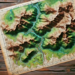
Wilderness Navigation Techniques for Your Off-Grid Journey
Master Essential Wilderness Navigation Techniques for Outdoor Adventures Without GPS
Gaining proficiency in wilderness navigation without modern technology may appear intimidating initially. However, developing fundamental map and compass navigation skills is an invaluable asset that significantly enhances your outdoor adventures. At its essence, navigation involves a deep comprehension of your surroundings and the ability to pinpoint your location concerning your intended destination. A map provides a comprehensive two-dimensional depiction of the terrain, while a compass offers a reliable means of orienting yourself using cardinal directions: north, south, east, and west. By mastering these essential tools, you can explore the great outdoors with confidence, unencumbered by technology.
Initiate your navigation journey by gaining a thorough understanding of the various symbols and scales that appear on a map; these elements are crucial for accurately interpreting the physical landscape. Learning to read contour lines, which illustrate changes in elevation, is vital. This skill enables you to identify hills, valleys, and other geographical features that might affect your route. Furthermore, becoming adept at using a compass is equally important, as it equips you with the ability to navigate successfully in the wilderness without depending on GPS devices.
The compass needle consistently points toward magnetic north, allowing you to align your map with the actual landscape. To accomplish this, hold the compass flat in your hand and rotate the map until the magnetic north indicated by the compass corresponds with the north marked on the map. This critical process, referred to as “orienting the map,” is foundational for maintaining precision in your navigation efforts and ensuring you remain on the correct path.
Once your map is accurately oriented, you can use the compass to take bearings that will guide your travel direction. By effectively combining these two powerful navigational tools—the map and the compass—you will confidently navigate through unfamiliar landscapes, ensuring you stay on course even without modern technological aids.
Fundamental Principles for Successful Outdoor Navigation
- Becoming proficient in map and compass navigation is essential for anyone involved in wilderness exploration or outdoor activities.
- Topographic maps provide intricate insights into the terrain, elevation, and natural features, crucial for successful navigation.
- A compass not only establishes direction but also enhances navigation by aligning with the map’s orientation and understanding magnetic north.
- Observing natural landmarks and cues, such as distinct rock formations or unique tree patterns, can serve as effective navigational aids in the absence of a map or compass.
- Estimating distance and travel time is vital for planning and executing a successful navigation strategy in wilderness settings.
Recognizing the Significance of Topographic Maps in Wilderness NavigationTopographic maps are essential tools for anyone planning to venture into the wilderness. They encompass a wealth of information about the physical features of the terrain, utilizing contour lines to represent elevation changes. This visual representation allows you to understand the shape and steepness of the landscape, making it easier to prepare for the challenges ahead. Each contour line connects points of equal elevation, and the spacing between these lines indicates whether a slope is steep or gradual, providing you with the necessary knowledge for effective navigation.
Decoding Contour Lines and Map Symbols for Enhanced Navigation
As you delve into a topographic map, it’s crucial to closely examine the patterns formed by contour lines; tightly spaced lines indicate steep terrain, while widely spaced lines denote flatter areas. This understanding empowers you to foresee potential obstacles along your route, enabling you to make informed decisions about navigation. Moreover, topographic maps are rich with symbols representing various landmarks, including rivers, roads, trails, and vegetation types. Familiarizing yourself with these symbols is fundamental for successful navigation, ensuring you can utilize the map effectively.
Refining Navigation Techniques with Topographic Maps
For instance, blue lines typically signify the presence of water bodies, such as streams or lakes, while green areas may indicate forests or dense vegetation. By cross-referencing these symbols with your surroundings, you can confirm your location and adjust your route as necessary. Additionally, topographic maps often feature grid lines that assist you in pinpointing coordinates, allowing for even more precise navigation. By mastering the intricacies of topographic maps, you will deepen your appreciation for the landscape and enhance your overall navigational skills in the wild.
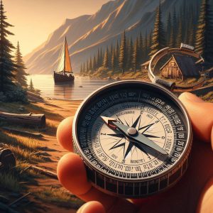 Developing Effective Directional Navigation Techniques Using a Compass
A compass is an essential tool for any adventurer, serving as a critical resource for directional navigation, especially when traversing unfamiliar landscapes. To use a compass effectively, start by holding it level in front of you, allowing the needle to stabilize. The needle will point toward magnetic north, which may slightly differ from true north due to magnetic declination—the angle between magnetic north and true north varies based on your geographical location.
Before embarking on your journey, it’s vital to determine the local declination and adjust your compass accordingly. This adjustment ensures that your bearings remain accurate, helping you stay on course throughout your adventure. Once your compass is calibrated for declination, you can proceed to take a bearing that will guide your travel direction.
To take a bearing, identify a landmark you wish to navigate toward and rotate the compass housing until the orienting arrow aligns with the magnetic needle. The degree reading on the compass dial that aligns with the index line indicates your bearing. As you move toward your destination, periodically check your bearing to confirm that you remain on track.
If you find yourself veering off course, reorient your compass and adjust your path as necessary. By mastering these techniques, you will gain the confidence to rely on a compass as a dependable navigational aid during any outdoor adventure.
 Utilizing Natural Landmarks and Cues for More Efficient Navigation
While maps and compasses serve as indispensable navigational tools, keenly observing natural landmarks and signs can greatly enhance your ability to navigate the wilderness effectively. Prominent features such as mountains, rivers, or unique trees can serve as invaluable reference points when traversing unfamiliar terrain. For example, if you know that a specific mountain lies to the east of your starting position, you can use it as a guide to ensure you’re headed in the right direction.
Moreover, familiarizing yourself with the unique characteristics of your surroundings will aid in forming mental maps that allow you to navigate without solely relying on tools. In addition to prominent landmarks, pay attention to natural signs that can indicate direction or changes in terrain. The sun’s position can serve as a helpful guide; in the northern hemisphere, the sun rises in the east and sets in the west, offering a general sense of direction throughout the day.
Additionally, observing moss growth on trees—often denser on the north side—can provide valuable clues about orientation in dense forests. Animal trails often indicate directional hints; many animals follow established paths that can lead you toward water sources or other significant landmarks. By refining your ability to interpret these natural signs, you will become increasingly adept at navigating diverse environments.
Effectively Estimating Distance and Travel Time for Reliable Navigation
Estimating distance and travel time is crucial for effective navigation in wilderness areas. Understanding how far you have traveled and how long it will take to reach your destination allows for improved planning and helps avoid unexpected challenges. One practical technique for estimating distance is pacing—counting your steps as you walk.
On average, an adult’s stride measures approximately 2.5 feet, meaning that by counting your steps over a known distance, you can estimate how far you’ve traveled based on your pace. Additionally, consider the type of terrain and elevation changes when calculating travel time. For instance, traveling over flat ground usually allows for quicker movement compared to navigating steep hills or rocky paths.
A common guideline suggests estimating that you can cover roughly three miles per hour on flat terrain, but this estimate should be adjusted significantly when faced with challenging landscapes. By taking these variables into account and modifying your expectations accordingly, you will be better equipped for your journey and more capable of managing your time effectively.
Creating a Strategic Wilderness Route and Navigation Plan for Success
Designing Your Wilderness Route for Optimal Navigation
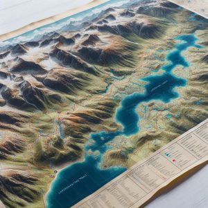
Creating an effective navigation plan is essential before embarking on any wilderness adventure. Start by studying topographic maps of the area you plan to explore, identifying potential routes based on prominent landmarks, existing trails, and accessible water sources. As you devise your route, consider factors such as elevation changes and the difficulty level of the terrain; ensuring your plan is realistic and achievable is paramount.
Preparing for Unexpected Obstacles and Environmental Changes
While planning your route, it’s wise to consider alternative paths in case you encounter unexpected obstacles or sudden changes in weather. Having multiple options will grant you greater flexibility during your journey and help ensure your safety. This adaptability is crucial for a successful and enjoyable wilderness experience, allowing you to navigate any challenges that may arise with ease.
Formulating a Comprehensive Navigation Strategy for Your Adventure
After mapping out potential routes, create a detailed navigation plan that includes critical waypoints. Mark these waypoints on your map and, if possible, note their coordinates, enabling you to track your progress as you navigate through the wilderness. Additionally, factor in estimated travel time between waypoints and identify any potential hazards you might encounter along your chosen route.
Ensuring Your Outdoor Experience is Safe, Enjoyable, and Rewarding
Thorough planning and anticipating challenges will enhance your chances of reaching your destination while enjoying a safe and fulfilling outdoor experience. A well-structured navigation strategy is vital for a successful wilderness adventure, ensuring that you can explore the great outdoors with confidence and assurance.
 Applying Emergency Navigation Techniques for Unforeseen Scenarios
Despite meticulous planning and preparation, unforeseen circumstances may arise during outdoor adventures that necessitate emergency navigation techniques. One essential skill is the ability to backtrack; if you find yourself lost or disoriented, retracing your steps can often lead you back to familiar territory. To execute this effectively, pay close attention to distinctive landmarks or features along your route, which can serve as reference points when returning.
Another invaluable technique is celestial navigation, particularly useful when visibility allows—especially during clear nights or sunny days when stars or celestial bodies are visible. Familiarizing yourself with prominent constellations, such as the North Star (Polaris) in the northern hemisphere, can guide you, as it remains relatively fixed in position while other stars shift. By locating Polaris and determining its angle above the horizon, you can ascertain true north, even without a compass or map.
If you have a watch or smartphone as a backup, utilizing it alongside celestial navigation can reinforce your sense of direction during emergencies, helping you maintain your orientation even in challenging situations.
Improving Your Wilderness Navigation Skills with Practical Strategies
Enhancing your wilderness navigation skills requires dedication and practice, but the rewards can significantly enrich your outdoor experiences. One effective approach is joining local hiking groups or outdoor clubs, where members can share their knowledge and experiences related to navigation techniques. Engaging with seasoned navigators can provide valuable insights into best practices while offering hands-on learning opportunities across various terrains.
Another beneficial strategy involves regularly practicing with maps and compasses in diverse environments—whether in urban settings or remote wilderness areas—to build your confidence in these essential skills. Dedicate time for solo excursions where you intentionally navigate without technological aids; this method will reinforce your abilities while allowing you to connect more deeply with nature. Additionally, consider maintaining a navigation journal to document routes taken, challenges encountered, and lessons learned during each adventure; this reflective practice will not only enhance your skills but also deepen your appreciation for navigating diverse landscapes.
By embracing these techniques and continuously refining your skills in map reading, compass usage, natural observation, distance estimation, route planning, emergency strategies, and sharing practical experiences with others, you will evolve into a more self-assured navigator, capable of thriving in any wilderness environment, even without the support of technology.
Your Questions Answered: Frequently Asked Questions About Wilderness Navigation
What skills are involved in wilderness navigation?
Wilderness navigation encompasses the skills needed to determine and maintain a route through natural, often remote, and undeveloped areas. It involves employing various tools and techniques to stay on course and safely reach a desired destination.
What traditional methods are effective in wilderness navigation?
Traditional methods of wilderness navigation include utilizing a map and compass, interpreting topographic features, observing natural landmarks, and employing celestial navigation techniques based on the sun, moon, and stars.
Why might individuals choose to navigate without GPS?
Many individuals opt to navigate without GPS for a variety of reasons, including the desire to enhance their wilderness navigation skills, enjoy the challenge of traditional methods, or prepare for potential GPS failures or limited access to technology.
What advantages come from learning wilderness navigation without relying on GPS?
Learning wilderness navigation techniques without GPS can deepen one’s understanding of the natural environment, increase self-reliance and confidence, and provide a backup plan in case of technology failures or limited access to GPS devices.
What challenges may arise when navigating in the wilderness without GPS?
Challenges associated with wilderness navigation without GPS include the need for advanced planning, the potential for human error, and reliance on environmental conditions such as weather and visibility.
The post Wilderness Navigation Techniques Without GPS appeared first on Survival Bite.
The Article Wilderness Navigation Techniques for Off-Grid Adventures Was Found On https://limitsofstrategy.com